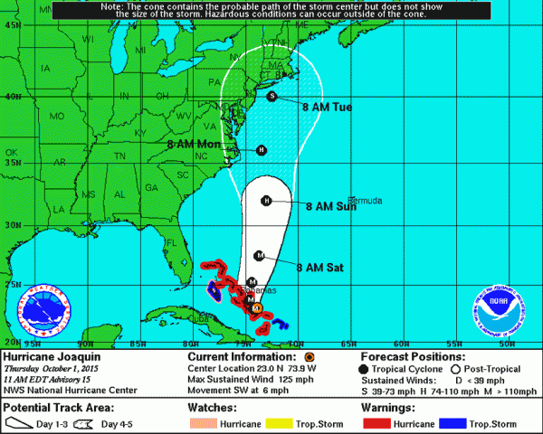
The latest “most likely” track from the National Weather Service has Hurricane Joaquin veering towards the east, which makes Northern Virginia less likely to take a direct hit from the now-Category 4 storm.
However, the National Hurricane Center and the NWS both say the Mid-Atlantic may still see effects from the storm.
“The details of how significantly the storm will impact us will become clearer as the week progresses,” says the NWS Washington-Baltimore. “Sunday into Monday is the most likely time. Be aware that flooding from heavy rain, damaging winds, and tidal flooding will be possible Sunday into Monday.”
But first…Friday and Saturday.
Regardless of where Joaquin makes landfall, the forecast is, forecasters are calling for heavy rains Friday and Saturday. Three to five inches of rain may fall here through Saturday morning — while up 10 inches is predicted for Central Virginia.
“We are preparing for the worst and hoping for the best,” Virginia Gov. Terry McAuliffe said at a news conference Thursday afternoon. “I hope Hurricane Joaquin turns and goes out into the ocean. That is what I am hoping for, but we have to prepare for the worst.”
McAullife, who issued a state of emergency for the commonwealth, warned citizens and governments to be aware that it is two systems weather forecasters are talking about.
“The first is going to occur,” he said. “The second we are monitoring.”
But if both system hit Virginia, McAuliffe said damage could be widespread. When asked if people could expect power outages, the governor said “if these two systems come together, it could be weeks. There are going to be major power outages with trees coming down. Flooding is going to affect every river in Virginia.”
Meanwhile, the governor said he has called up 700 National Guard troops, mainly t protect coastal Navy stations and NASA’s Wallops Island facility.
A flash flood watch is in effect for Reston and all of Northern Virginia on Friday and Saturday.
Fairfax County’s Emergency Information Office has these tips for staying safe and preparing for the storms.
Graphic: Updated Hurricane Joaquin forecast/Credit: NWS
Get ready for a rainy weekend as a front that could cause up to a half a foot of rain heads towards Reston, only to possibly be followed soon after by Hurricane Joaquin.
Here is what you need to know:
The National Weather Service has issued a Flash Flood Watch from Friday morning to Saturday evening. Rain will increase in intensity across the area Friday into Saturday, with two to four inches expected, with spots seeing higher amounts. Rain could fall over a short period of time on already saturated land.
Virginia Gov. Terry McAuliffe issued a state of emergency late Wednesday afternoon. The Executive Order operates retroactively to Tuesday, when parts of Virginia were deluged with 6 inches of rain.
The state of emergency allows state and local emergency responders to begin to prepare for the effects of rain forecast across the Commonwealth Thursday and Friday, as well as the potential that Hurricane Joaquin will impact Virginia.
“I cannot stress enough the imperative for Virginians to focus on the rainstorms that are headed our way tomorrow and Friday, well before Hurricane Joaquin could potentially impact Virginia,” Governor McAuliffe said in a statement.
“The forecast of up to 10 inches of rain in areas across Virginia could result in floods, power outages and a serious threat to life and property. As we continue to track the path of Hurricane Joaquin, I have instructed the Secretary of Public Safety and Homeland Security to make every preparation for a major event Thursday and Friday.”
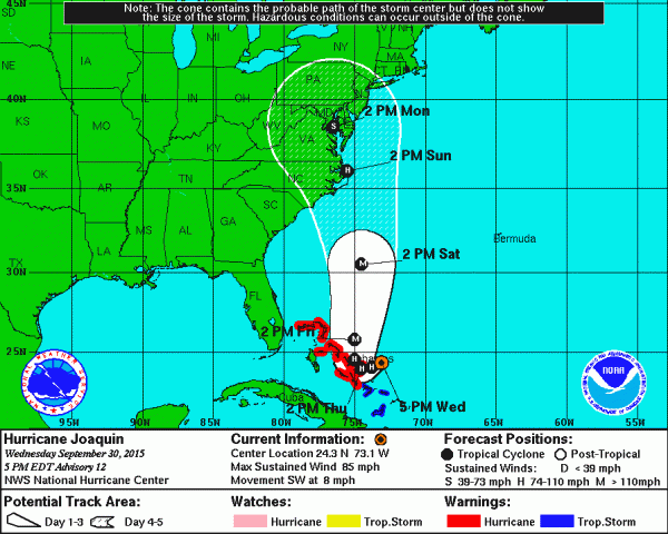
The National Weather Service declared Joaquin a hurricane Wednesday morning when it was several hundred miles East-Northeast of the central Bahamas with winds of up to 85 mph. By Wednesday night, Joaquin had strengthened to a Category 3 (120 mph winds).
Said the NWS: “The storm may move closer to the Mid-Atlantic during the next several days. The details of how significantly the storm will impact us will become clearer as the week progresses. If it does impact us, sometime between late Friday through Monday is the most likely time. If the storm does reach the Mid-Atlantic be aware that heavy rain, wind, and tidal flooding will be possible.”
The Capital Weather Gang said on Wednesday “there’s no need to panic, but simply to begin thinking about hurricane and flooding preparedness and remaining tuned to the forecast, as it is likely to evolve substantially over the next 72 hours.”
“Hurricane Joaquin is forecast to come very close to the Mid-Atlantic coast, and possibly move inland, said the Capital Weather Gang. “At the very least, a period of heavy rain is likely. In a worst-case scenario, the region could contend with a dangerous, long-duration flooding event, widespread damaging winds and a significant surge of water up the Chesapeake Bay and Potomac River.”
Some computer models have Joaquin making landfall in North Carolina; other say it will stay off shore.
Some weekend events may be altered due to the storm. Herndon High’s football game at Tuscurora has already been moved from Friday night to tonight. Washington Redskins and DC United officials also say they are monitoring developments that may affect weekend games.
Reston Now will update this story as it develops.
Graphic courtesy National Weather Service


