(Updated at 10:45 p.m.) There are numerous reports of trees down and emergency activity around Reston following a tornado touchdown Friday night.
Around 10:20 p.m. the National Weather Service confirmed that a tornado had touched down, after reporting extensive tree damage in the area.
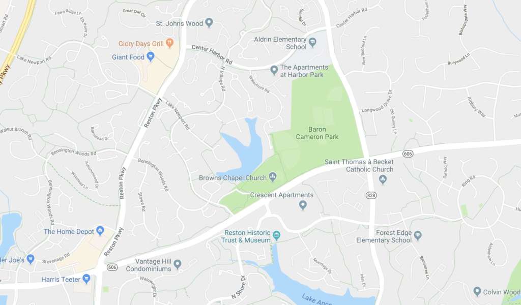
“911 call center reports… multiple trees down in the Reston area with ones reported on Center Harbor Road and Baron Cameron Road,” said a storm damage report from the weather service. Emergency activity has also been reported along the Reston Parkway and Wiehle Avenue.
“Tree damage near intersection of Quietree Drive and Crosswind Drive,” NWS further reported. “One house condemned with tree falling through roof.”
The weather service will determine the tornado’s intensity via a storm survey during daylight hours on Saturday.
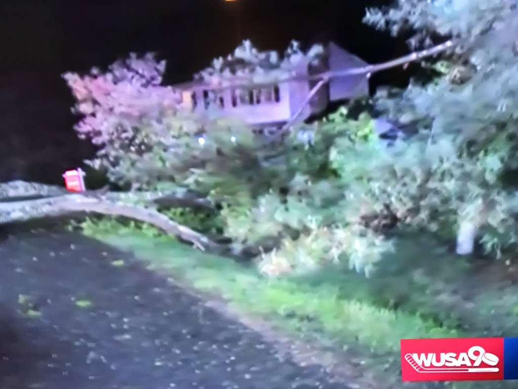
One large fallen tree crushed a pickup truck on Center Harbor Road. NBC 4’s Darcy Spencer reported that the truck’s owner was taking shelter inside his home as the storm roared past.
On Reston Now’s Facebook page residents shared their harrowing experiences and damage reports.
“I’m just off Bennett Road and I am pretty sure we had a tornado go through our backyard (or very close to it) around 8:45/8:50,” said one reader. “It was, literally, as the warning was going out. Spoke with several neighbors who heard it as well and took shelter in the basement. Tons of debris on our street and quite a bit on Bennett.”
“We heard a huge amount of wind and then several large big bangs… several large branches fell onto our house and were swept into the backyard,” said another resident. “The force of the large branches was so strong the drywall inside is busted in two places on the other side of this scar… So thankful our family is safe.”
The original Tornado Warning from NWS:
THE NATIONAL WEATHER SERVICE IN STERLING VIRGINIA HAS ISSUED A
* TORNADO WARNING FOR… SOUTHEASTERN LOUDOUN COUNTY IN NORTHERN VIRGINIA… NORTHWESTERN FAIRFAX COUNTY IN NORTHERN VIRGINIA…
* UNTIL 915 PM EDT.
* AT 853 PM EDT, A SEVERE THUNDERSTORM CAPABLE OF PRODUCING A TORNADO WAS LOCATED OVER RESTON, MOVING NORTHEAST AT 55 MPH.
HAZARD…TORNADO.
SOURCE…RADAR INDICATED ROTATION.
IMPACT…FOR THOSE IN THE DIRECT PATH OF A TORNADO TOUCHDOWN, FLYING DEBRIS WILL BE DANGEROUS TO THOSE CAUGHT WITHOUT SHELTER. DAMAGE TO ROOFS, SIDING, AND WINDOWS MAY OCCUR. MOBILE HOMES MAY BE DAMAGED OR DESTROYED. TREE DAMAGE IS LIKELY.
* LOCATIONS IMPACTED INCLUDE… RESTON, HERNDON, LOWES ISLAND, ASHBURN, STERLING, CHANTILLY, GREAT FALLS, COUNTRYSIDE AND STERLING PARK.
Storm reports and photos via social media:
https://twitter.com/emcerlain/status/1119416891519451136
Better picture pic.twitter.com/6SKakZ73sy
— Not A Robot (@TestForEcho12) April 20, 2019
BREAKING: massive tree down on Center Harbor Road in RESTON @fox5dc pic.twitter.com/hhCGBkaduF
— Ike Ejiochi (@IkeEjiochi) April 20, 2019
I'm up near Armstrong elementary, and near Fairfax County Parkway, it's not bad at all. But drive up lake Newport towards Reston Parkway and you start seeing the downed trees. Stay safe, watch extended to midnight.
— #RaiseHail (@DefiantRF) April 20, 2019
Calls from @ffxfirerescue seem to point to a storm path that came up from South West #Reston – crossed #Reston Parkway heading North East over Center Harbor – and then Wiehle Ave.
— Reston (@Reston) April 20, 2019
Emergency vehicles pulling into Whisper Hill community in #Reston VA after #tornado. pic.twitter.com/gWsCoZ7M1b
— Angela (@bemindfulhappy) April 20, 2019
So was there a tornado in Reston? From this brief radar analysis a tornado may have touched down. @AdamMooreWX @nova_weather_ce @capitalweather pic.twitter.com/IWBHErHw2M
— Marios Wallace (@Marios_WX) April 20, 2019
CHANNEL 9 – "PRETTY CLEAR TORNADO SIGNATURE" – Loud noise – roar – reported from #Reston Town Center – possible transformer explosion.
— Reston (@Reston) April 20, 2019
Rotation for the Tornado Warning within #fairfax County is right over #restonVA. TAKE COVER NOW from Reston to Great Falls!! @wtop pic.twitter.com/IUEhPyePVZ
— Matt Ritter, Multi-Platform Meteorologist (@MetMattRitter) April 20, 2019
House shaken, loud roar, pounding rain & pebbles against the siding over here around 9pm in the Whisper Hill community in #Reston VA. Do we have #tornado touchdown confirmation? pic.twitter.com/wAMyvMja0F
— Angela (@bemindfulhappy) April 20, 2019
https://twitter.com/emcerlain/status/1119407672741249024
Reston Hospital, Aldrin Elementary — if you live near these landmarks, seek shelter NOW! More on @wusa9 & https://t.co/RkDeb8dzXs #wusa9weather pic.twitter.com/g83tAySGPp
— Howard Bernstein (@hbwx) April 20, 2019
https://twitter.com/bdwy27/status/1119415225793511426
One of two trees down on Fort Lee St. at Folkstone Dr. in Herndon, just south of Reston. pic.twitter.com/NFSBoqDvUr
— Mary Southard (@MarySouthard) April 20, 2019
heard the tornado warning for North Reston and went down to the basement. What I saw later made me glad I did that. pic.twitter.com/pTgQYXnKzs
— Leanne Wiberg (@craterlady) April 20, 2019
Recent Stories

Owners of six Woofie’s franchises in Northern Virginia are hosting a “Paws in the Park” pet adoption event tomorrow (Saturday) at Wolf Trap National Park. Participating Woofie’s include Reston/Herndon, Ashburn-Leesburg,…

A Fairfax Connector bus to Tysons (staff photo by James Jarvis) The Fairfax County Department of Transportation (FCDOT) has the green light to apply for a federal grant to replace…

The splash pad at the Mosaic District in Merrifield has been turned on (staff photo by Angela Woolsey) Congress Approves More National Airport Flights — “More long-haul flights are coming…

Fairfax County’s annual Summer Entertainment Series will kick off on June 1 (via Fairfax County Park Authority/Twitter) The Fairfax County Park Authority has composed a slate of summer shows, including…