
Lakes Under Focus in Reston Association Meeting — The organization is hosting an informational meeting on lake management on March 31 via Zoom. All members are encouraged to take part. [RA]
Save the Date — National Drug Take-Back Day is on Saturday, April 24 from 10 a.m. to 2 p.m. The Fairfax County Police Department will be offering a number of drop-off locations, which will be announced via social media soon. [FCPD]
County Funds for Rental Assistance Now Available — Funds are now available for landlords who are seeking rental assistance on behalf of their tenants. [Fairfax County Government]
Tornado Drill Set for Today — Vriginia’s annual tornado drill take take place at 9:45 a.m. The drill is part of Virginia’s Severe Weather Awareness Week initiative. [Fairfax County Government]
Photo via vantagehill/Flickr

Great Falls Fire Captain Honored — The Greater Reston Chamber of Commerce honored Capt. Mike Allen as the first responder of the year. He works in the Fairfax County Fire and Rescue Department’s Station 12 in Great Falls. [Inside NOVA]
South Lakes Students Make School More Inviting — Students at South Lakes High School beautified bathroom stalls with paintings in order to make the return to school more inviting. The effort was coordinated by the school’s campus environment commission committee. [Fairfax County Public Schools]
County Board Advertises Flat Tax Rate — The Fairfax County Board of Supervisors voted yesterday to set an advertised real estate tax rate of $1.15 per $100 of assessed value for fiscal year 2022. County Executive Bryan Hill had proposed decreasing the rate by one cent. [@JeffreyCMcKay/Twitter]
Severe Tornado Drill Set for March 16 — “Virginia Severe Weather Awareness Week, which is the first time Virginia is promoting this combined awareness effort, will be held March 15-19…As part of the awareness week activities, Virginia’s annual tornado drill will be conducted on Tuesday, March 16, at 9:45 a.m.” [Fairfax County Government]
Photo via vantagehill/Flickr
")
Fairfax County is under a Tornado Watch until 10 p.m. today (Thursday).
The National Weather Service issued the alert shortly after 3:30 p.m.
Forecasters say that residents in the Reston-area may see heavy thunderstorms this evening.
Be Aware: There is a POTENTIAL for TORNADOES and DAMAGING WIND GUSTS from severe thunderstorms this afternoon & early tonight for a large part of our area. Stay weather aware & be ready to seek shelter if warnings are issued or severe weather threatens. #vawx #mdwx #dcwx #wvwx pic.twitter.com/GB9xtpM4WE
— NWS Baltimore-Washington (@NWS_BaltWash) September 3, 2020
BREAKING: Tornado watch issued for entire region until 10 p.m. Storms with torrential rain, localized damaging winds likely through this evening. A few tornadoes cannot be ruled out.
Updates: https://t.co/5SDZ7bq9nl pic.twitter.com/k08D1HvUJ7
— Capital Weather Gang (@capitalweather) September 3, 2020
Stay weather alert this afternoon and evening as scattered to numerous severe storms are expected to move across our area from west to east. The main threat will be damaging wind gusts, but tornadoes cannot be ruled out. For the latest forecast visit https://t.co/t54l4ELo2o pic.twitter.com/UwlivesMBs
— NWS Baltimore-Washington (@NWS_BaltWash) September 3, 2020
Photo via Flickr/house of cards
")
(Update at 3:48 p.m.: The watch as canceled in the afternoon).
A tornado watch is in effect for Fairfax County until 6 p.m. today.
The county is already under a wind advisory and storms are expected to roll through the region for most of the day.
A severe thunderstorm warning is also in effect until 2:30 p.m. today.
High winds are currently ongoing across much of the area, with the strongest winds across Southern Maryland. The initial line of storms has moved out of the area but another round of storms is expected to form over the next couple of hours. pic.twitter.com/H80xV5DN6T
— NWS Baltimore-Washington (@NWS_BaltWash) April 13, 2020
Severe Thunderstorm Warning including Rockville MD, Bethesda MD, Reston VA until 2:30 PM EDT pic.twitter.com/UTZirbYp4Z
— NWS Severe Tstorm (@NWSSevereTstorm) April 13, 2020
A tornado watch is in effect for Fairfax County until, according to the National Weather Service.
The alert is in effect until midnight tonight (Thursday).
A tornado watch has been issued for parts of southern Virginia and northwestern North Carolina until 11 PM EDT pic.twitter.com/yBY7lLMKAV
— NWS Eastern Region (@NWSEastern) October 31, 2019
")
A severe thunderstorm tornado warning is in effect for Fairfax County until 3:15 p.m. today (Friday). The National Weather Service issued the alert this afternoon.
Residents are encouraged to take shelter immediately.
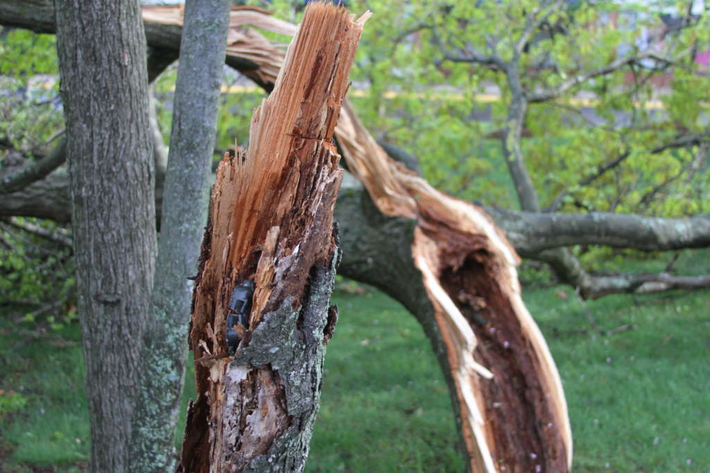
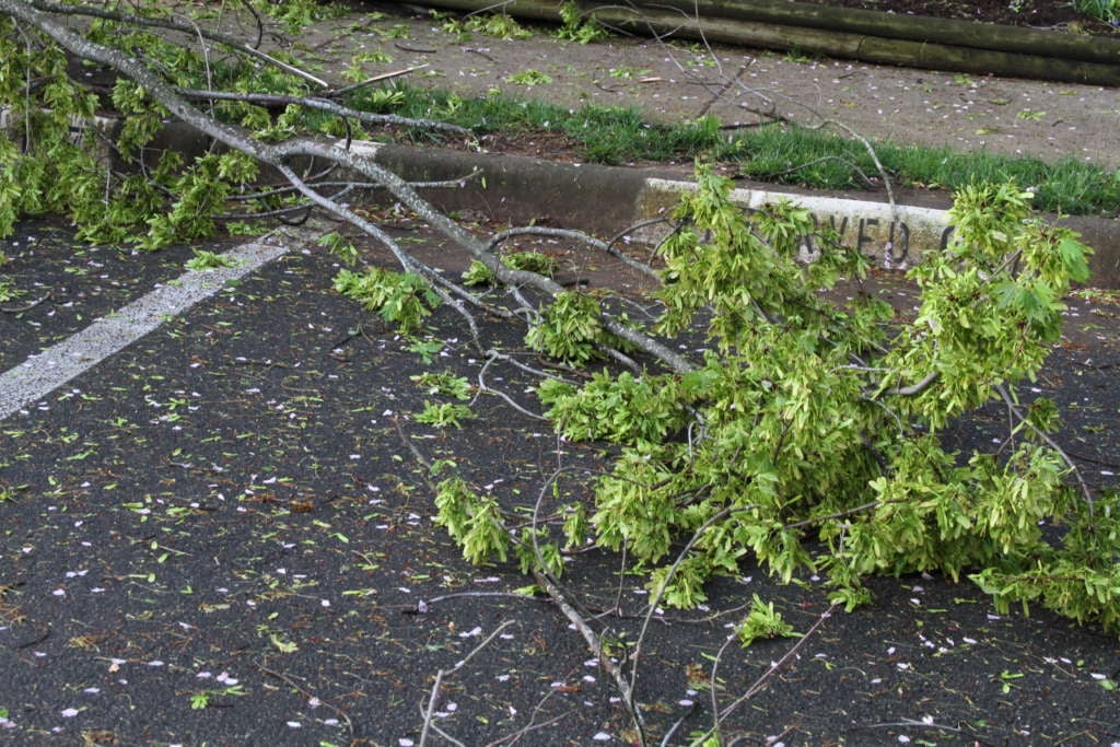
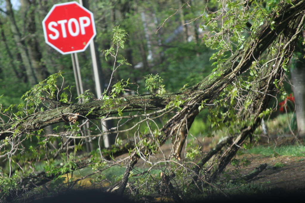
The alert comes one week after a small tornado touched down in Reston. NWS classified the tornado as weak, but it left downed trees and destroyed one Reston home.
Reston Association staff worked to clear downed trees on its properties this week. Property owners should contact insurance companies or tree removal companies to remove downed trees from their yards.
 This is an opinion column by Del. Ken Plum, who represents Reston in Virginia’s House of Delegates. It does not reflect the opinion of Reston Now.
There was both shock and amazement on the part of many Restonians to hear last Friday evening that our community was under a tornado warning by the National Weather Service (NWS). These warnings occur all the time especially in the Midwest and earlier that day across the deep South. For us the weather is relatively mild, although the winds do seem to blow harder these days, and the rains this spring seem to have brought a lot of local flooding. The amount of snow varies from winter to winter.
About 8:30 p.m. on Friday the National Weather Service found that an approaching squall line ahead of a larger storm’s cold front distorted into an S shape across Northern Virginia. Gusts along the bow were significant until the bow broke up into a rotating storm. Doppler radar revealed a counterclockwise circulation known as a mesocyclone over Reston that developed into a cyclone.
Technically the National Weather Service recorded that on Friday, April 19, there was a tornado event in Reston beginning at 8:55 p.m. estimated time with estimated maximum wind speed of 70 mph, with a maximum path width of 100 yards and a path length of 4 miles. The NWS uses the Fujita Scale to classify tornadoes into one of six categories–EF0 (weak) to EF5 (violent). The tornado in our community was rated at the lowest ranking, EF0.
For professional weather people who deal with bad weather all the time, the tornado in our community that lasted an estimated five minutes may have seemed weak. But for those who sought refuge in their basements and heard the wind whipping around their homes and saw the trees swaying in their yards the storm was anything but weak. Fortunately, no one was killed or reported hurt. Lots of trees and branches were downed and several cars were damaged with one townhouse being severely damaged. Everyone is left to wonder if we will be as lucky if the flukes of weather send their wrath on us again.
Weather refers to what happens in the atmosphere around us with rain, snow, wind, and thunderstorms as examples. For many of us weather conditions seem to have become more severe. Only scientific recordings of weather events over a long period of time will provide evidence needed to confirm or deny our hunches. All the weather events of temperature, humidity and rainfall patterns averaged over seasons, years or longer creates our climate. There is ample evidence to demonstrate that climate is changing and that human behavior especially in releasing more heat-trapping gases into the atmosphere is a leading cause. Completing the circle of what is happening in our world is that climate change is bringing about more extreme weather events.
While extreme weather, climate change and global warming may be controversial topics to some, many of us are deeply concerned. This week’s celebration of Earth Day was a global experience. Our local weather event while relatively mild reminds us that we need to be serious about the subject and serious about our response to it.
File photo
")
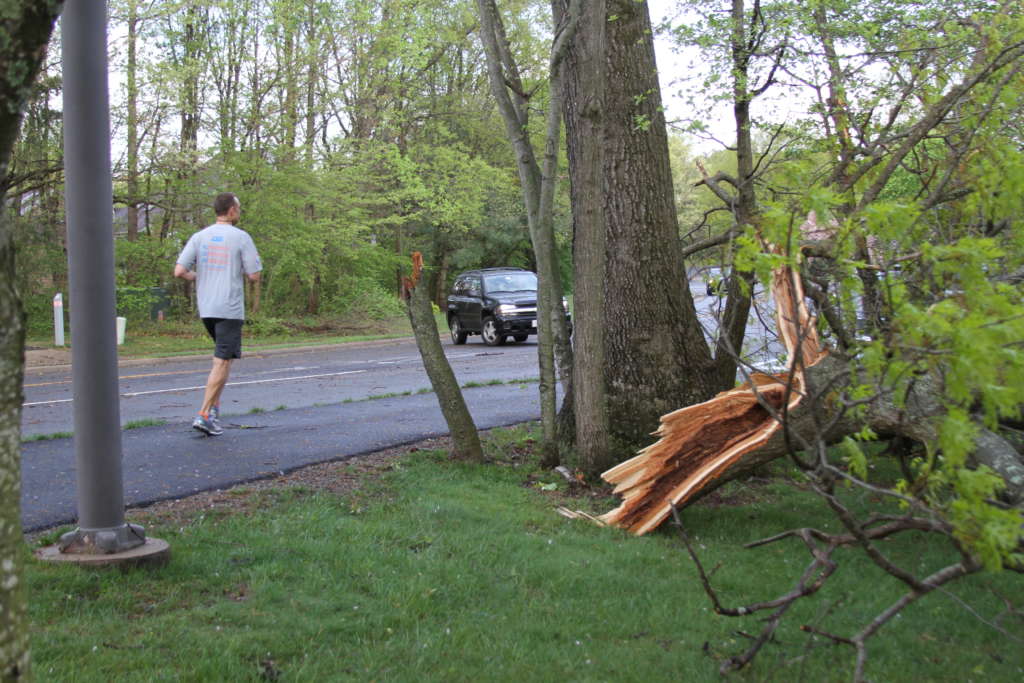
The tornado that touched down Friday night in Reston was classified by the National Weather Service as weak.
The tornado was rated “EF0,” which is the weakest classification for a tornado. Peak winds reached 70 miles per hour and the tornado’s path was up to 100 yards wide, according to NWS.
Cleanup was underway on Saturday and no injuries were reported.
According to a damage assessment and report released Saturday afternoon, NWS stated that the tornado, which touched down at 9 p.m., lasted five minutes and left a four-mile path of uprooted trees.
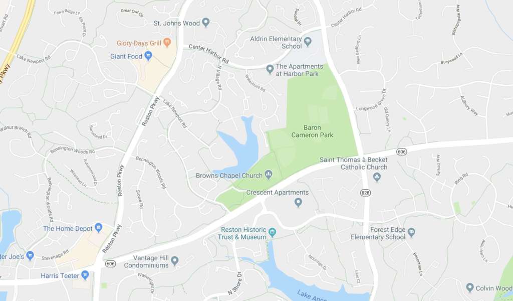
It began near Fox Mill Road and Pinecrest Road and made its way down to Center Harbor Road and Wiehle Avenue.
NWS charted the complete path in its assessment:
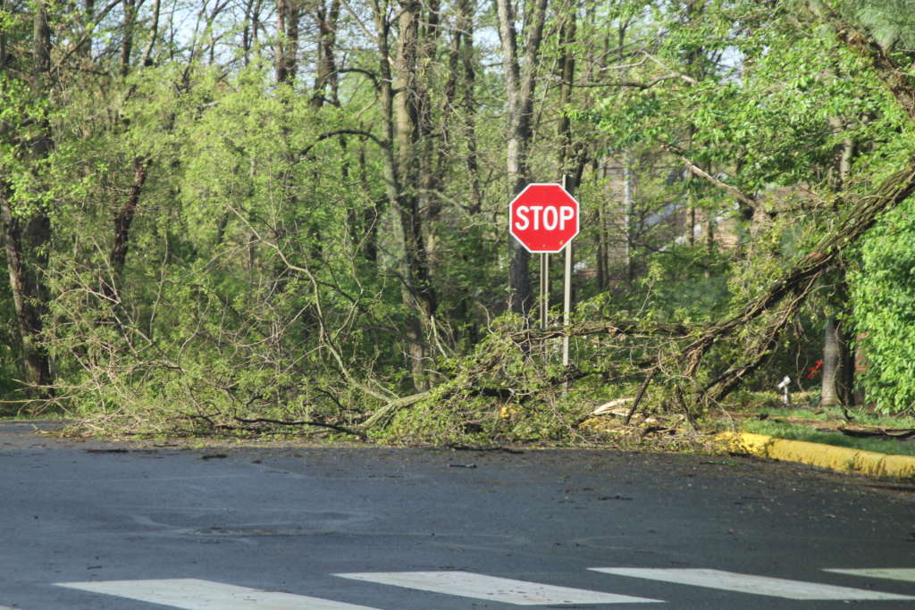
FIRST EVIDENCE OF DAMAGE WAS NEAR FOX MILL ROAD AND PINECREST ROAD WHERE SEVERAL TREES WERE DOWNED AT APPROXIMATELY 855 PM EDT. ISOLATED TREE DAMAGE FROM THIS POINT TO NEAR THE U.S. GEOLOGICAL SURVEY COMPLEX ON SUNRISE VALLEY DRIVE WAS NOTED, WITH SEVERAL TREES TOPPED ALONG GLADE DRIVE NEAR ROSEDOWN DRIVE.
AFTER PASSING ACROSS THE DULLES TOLL ROAD (ROUTE 267), MINOR TREE DAMAGE WAS NOTED BETWEEN SUNSET HILLS ROAD AND BARON CAMERON AVENUE. THE TORNADO TRACKED ACROSS RESTON HOSPITAL CENTER, WITH NO VISIBLE SIGNS OF DAMAGE, BUT DAMAGE WAS NOTED JUST NORTH OF THE HOSPITAL ON TOWN CENTER DRIVE NEAR TOWN CENTER PARKWAY, WHERE A TREE WAS TOPPED, FENCING BLOWN DOWN, AND SHINGLES BLOWN OFF SEVERAL TOWNHOUSES.
AFTER CROSSING BARON CAMERON AVENUE, THE TORNADO PASSED JUST EAST OF TRADER JOE’S GROCERY STORE DESTROYING AN OUTDOOR SHED THERE. NEARBY, A TALL, TWO-FOOT DIAMETER TREE CRASHED THROUGH THE UPPER FLOOR OF A TOWNHOUSE ON QUIETREE DRIVE IN RESTON, THAT LED LOCAL OFFICIALS TO CONDEMN THE PROPERTY. SEVERAL LARGE TREES WERE EITHER UPROOTED OR TOPPED ALONG BENNINGTON WOODS ROAD BETWEEN CROSSWIND DRIVE AND RESTON PARKWAY.
A LARGE, 100-FOOT TALL TREE FELL AND SMASHED THE FRONT END OF AN UNOCCUPIED VEHICLE PARKED ALONG CENTER HARBOR ROAD, MIDWAY BETWEEN RESTON PARKWAY AND NORTH VILLAGE ROAD. MINOR TREE DAMAGE ALONG A NARROW PATH WAS NOTED IN NEIGHBORHOODS LOCATED BETWEEN NORTH VILLAGE ROAD AND RESTON PARKWAY BETWEEN CENTER HARBOR ROAD AND WIEHLE AVENUE. NO SUBSTANTIAL STORM DAMAGE WAS NOTED NORTH OF WIEHLE AVENUE, WHERE IT APPEARS THE TORNADO WEAKENED AT 900 PM EDT.
Photo by Fatimah Waseem
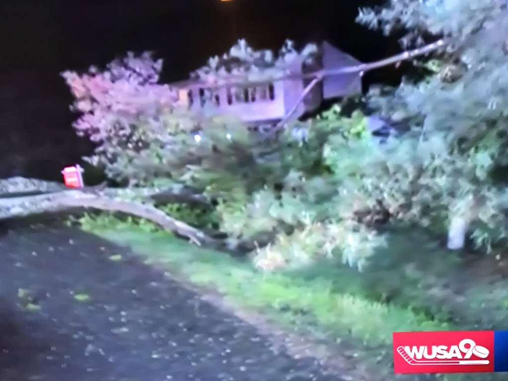
The calm after the storm has descended after a tornado touched down briefly Friday night.
Local fire and rescue personnel spent much of the night clearing a tree that had fallen on a parked pickup truck on Center Harbor Road in Reston. Crews used chainsaws to cut up the tree to open the road. The truck’s owner was not inside the truck at the time.
Scattered downed trees still rested on roads and sidewalks early Saturday morning, including several near Lake Anne Village Center. A house near Quietree and Crosswind Drives was condemned after a tree fell through the roof.
Although the National Weather Service confirmed the tornado touched down, the service has not yet determined the severity of the storm. It will make an announcement after a storm survey during daylight hours today (Saturday).
Restonians reported whistling winds and punctuated bangs that suggest the tornado moved from Bennett Road to the Wiehle Avenue and Lakeport Recreation Area.
Send photos of the damage to [email protected] and tell us how the storm impacted you.
Here’s more from social media a day after the storm:
Around 9 pm last night, crews dispatched to Center Harbor Rd between Reston Pkwy and North Village Rd for large tree that fell on a parked pick truck. Fortunately no one was in vehicle. Tree completely blocked street so crews used chainsaws to cut up tree to open road up. #FCFRD pic.twitter.com/YW2haaHeqn
— Fairfax County Fire/Rescue (@ffxfirerescue) April 20, 2019
Had this been the 1990s, last night’s tornado in Reston would have hit the emergency room where my late mother worked night shift. A mile later, it would have struck the house where my parents lived. What are the odds?! Fortunately, there was only light damage to property. https://t.co/LzAyNVjWGn
— Sanho Tree (@SanhoTree) April 20, 2019
https://twitter.com/MikeIserman53/status/1119582611750432768
Photos by Fatimah Waseem. This story will be updated.
(Updated at 10:45 p.m.) There are numerous reports of trees down and emergency activity around Reston following a tornado touchdown Friday night.
Around 10:20 p.m. the National Weather Service confirmed that a tornado had touched down, after reporting extensive tree damage in the area.
“911 call center reports… multiple trees down in the Reston area with ones reported on Center Harbor Road and Baron Cameron Road,” said a storm damage report from the weather service. Emergency activity has also been reported along the Reston Parkway and Wiehle Avenue.
“Tree damage near intersection of Quietree Drive and Crosswind Drive,” NWS further reported. “One house condemned with tree falling through roof.”
The weather service will determine the tornado’s intensity via a storm survey during daylight hours on Saturday.
One large fallen tree crushed a pickup truck on Center Harbor Road. NBC 4’s Darcy Spencer reported that the truck’s owner was taking shelter inside his home as the storm roared past.
On Reston Now’s Facebook page residents shared their harrowing experiences and damage reports.
“I’m just off Bennett Road and I am pretty sure we had a tornado go through our backyard (or very close to it) around 8:45/8:50,” said one reader. “It was, literally, as the warning was going out. Spoke with several neighbors who heard it as well and took shelter in the basement. Tons of debris on our street and quite a bit on Bennett.”
“We heard a huge amount of wind and then several large big bangs… several large branches fell onto our house and were swept into the backyard,” said another resident. “The force of the large branches was so strong the drywall inside is busted in two places on the other side of this scar… So thankful our family is safe.”
The original Tornado Warning from NWS:
THE NATIONAL WEATHER SERVICE IN STERLING VIRGINIA HAS ISSUED A
* TORNADO WARNING FOR… SOUTHEASTERN LOUDOUN COUNTY IN NORTHERN VIRGINIA… NORTHWESTERN FAIRFAX COUNTY IN NORTHERN VIRGINIA…
* UNTIL 915 PM EDT.
* AT 853 PM EDT, A SEVERE THUNDERSTORM CAPABLE OF PRODUCING A TORNADO WAS LOCATED OVER RESTON, MOVING NORTHEAST AT 55 MPH.
HAZARD…TORNADO.
SOURCE…RADAR INDICATED ROTATION.
IMPACT…FOR THOSE IN THE DIRECT PATH OF A TORNADO TOUCHDOWN, FLYING DEBRIS WILL BE DANGEROUS TO THOSE CAUGHT WITHOUT SHELTER. DAMAGE TO ROOFS, SIDING, AND WINDOWS MAY OCCUR. MOBILE HOMES MAY BE DAMAGED OR DESTROYED. TREE DAMAGE IS LIKELY.
* LOCATIONS IMPACTED INCLUDE… RESTON, HERNDON, LOWES ISLAND, ASHBURN, STERLING, CHANTILLY, GREAT FALLS, COUNTRYSIDE AND STERLING PARK.
Storm reports and photos via social media:
https://twitter.com/emcerlain/status/1119416891519451136
Better picture pic.twitter.com/6SKakZ73sy
— Not A Robot (@TestForEcho12) April 20, 2019
BREAKING: massive tree down on Center Harbor Road in RESTON @fox5dc pic.twitter.com/hhCGBkaduF
— Ike Ejiochi (@IkeEjiochi) April 20, 2019
I'm up near Armstrong elementary, and near Fairfax County Parkway, it's not bad at all. But drive up lake Newport towards Reston Parkway and you start seeing the downed trees. Stay safe, watch extended to midnight.
— #RaiseHail (@DefiantRF) April 20, 2019
Calls from @ffxfirerescue seem to point to a storm path that came up from South West #Reston – crossed #Reston Parkway heading North East over Center Harbor – and then Wiehle Ave.
— Reston (@Reston) April 20, 2019
Adding to expected rain and a flood watch, a tornado watch has been issued from now until midnight.
The National Weather Service issued the alert at 12:49 p.m. today. The watch covers Maryland, the District, ad 34 counties in Virginia, including Fairfax County and Arlington.
Potential for widespread damaging winds and some tornadoes today across parts of the Southeast and Mid Atlantic regions. Tornado Watches have been issued for parts of Georgia, South and North Carolina, and southwestern Virginia. pic.twitter.com/MTGRpt8VLV
— NWS Eastern Region (@NWSEastern) April 19, 2019
")
Statewide tornado drill today — Don’t be surprised if your neighbors act there’s a tornado, because there’s a statewide drill starting at 9:45 a.m. [Reston Now]
Reston makes the list — Find out which Reston developments made the Washington Business Journal’s “Best Real Estate Deals” roundup. [Washington Business Journal]
Hudgins interview — Hunter Mill District Supervisor Cathy Hudgins might be stepping down from her Fairfax County Board of Supervisor’s role, but locals can still expect to see her around Reston. Hudgins answered some questions about development, One Fairfax and more. [Inside NoVa]
Photo courtesy @thoroughly.adorable.millie/Instagram
")
Fairfax County wants locals to sign up for the upcoming statewide tornado drill.
The annual drill is meant to help prepare residents for tornadoes, which can strike quickly and cause extensive damage. Virginia has averaged 24 tornadoes per year over the last 10 years, according to the county.
After locals sign up to participate, the National Weather Service will send a test tornado warning over NOAA Weather Radios at 9:45 a.m. on March 19.
The test should come through a tone or message alert simulating what people would hear and see during an actual tornado. Local radio stations, TV stations and cable outlets will also participate by broadcasting the test message.
Once the drill starts, here’s what to do: move to a safe area, crouch, face down and cover your head with your hands. Some examples of safe areas include sturdy buildings, basements and storm cellars.
If you are in a car or outdoors, cover your head and neck and try to cover your body with a blanket or coat.
Here are things not to do:
- do not outrun a tornado in a vehicle
- do not go underneath an overpass or bridge
- do not stay near windows, doors and outside walls
Image via Fairfax County
Update: The tornado watch was canceled around 8:11 p.m. today (September 17), but the National Weather Service still expects heavy rains to continue through the night.
Earlier:
The National Weather Service has issued a tornado watch effective until 10 p.m today (September 17).
Tornadoes are possible as Hurricane Florence’s remnants move past the area.
#Florence has arrived! 🌧 Please be mindful of changing road conditions and remember to use your headlights when using your wipers. #VirginiaLaw pic.twitter.com/FcqTBmZAsR
— Fairfax County Police (@FairfaxCountyPD) September 17, 2018
A tornado watch has been issued for parts of District of Columbia, Maryland and Virginia until 10 PM EDT pic.twitter.com/4CDThHFJfU
— NWS Baltimore-Washington (@NWS_BaltWash) September 17, 2018

Road closures in Reston — Browns Mill Road at Windstone Drive and Browns Mill Road at Rosewood Hill Drive are closed due to water in the roadway. One lane is open near Lee Mill Road at Kelso Road. [Fairfax County Police Department]
Town of Herndon job opening — Town officials are looking for a new director of public works. The position pays between $120,000 and $140,000. [Town of Herndon]
PRC exchanges continue — The Coalition for a Planned Reston penned a letter to Hunter Mill District Supervisor Cathy Hudgins about a recent parks and open space meeting with the county. [Reston 20/20]
Nearby: Tornado touches down on Tuesday — “The National Weather Service confirmed Tuesday evening that an early morning tornado touched down for about a minute in the Lincolnia area.” [WTOP]
Photo by Ruth Sievers