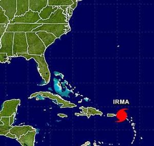
 As the southeast U.S. prepares for the onslaught of Hurricane Irma, the National Weather Service in DC/Baltimore says the Mid-Atlantic region should be paying attention as well.
While the storm will likely dwindle after weekend landfall, the NWS says it may still be able to pack a punch between Monday and Wednesday of next week if its track takes it up the Eastern Seaboard to our region. According to the NWS, if the storm tracks here, threats it will bring will include damaging winds, possible tornados and flooding brought on by rainfall. Tidal flooding is also a concern for coastal area.
“Families and businesses should ready their disaster plans and kits,” the NWS warns.
Residents are encouraged to monitor the National Weather Service in DC/Baltimore, as well as the National Hurricane Center, for updates on the track and power of the storm as it continues through the rest of this week and into the weekend.
The new track has a slight shift to the east. Irma set to impact southern Florida over the weekend as major category 4. Rains here Tue/Wed https://t.co/5lxRsi6KNc
— Amelia Draper (@amelia_draper) September 6, 2017
The remnants of Hurricane Harvey passed through our area last Friday and Saturday, bringing heavy rain at times and forcing the cancelation of events including the Lake Anne Jazz & Blues Festival.


