 The National Weather Service (NWS) issued a Flood Watch today (Dec. 20) starting from 7 p.m. Thursday to Friday afternoon for Fairfax and much of the D.C. region.
NWS anticipates widespread rain tonight and showers tomorrow.
NWS expects 1 to 2 inches of rain, but up to 4 inches of rain could fall in local areas.
NWS encourages locals to monitor later forecasts and to stay alert for possible Flood Warnings. Residents should prepare to take action if they live in areas prone to flooding.
More from the National Weather Service:
FLOOD WATCH REMAINS IN EFFECT FROM 7 PM EST THIS EVENING
THROUGH FRIDAY AFTERNOON…The Flood Watch continues for
* Portions of Maryland, The District of Columbia, Virginia, and
West Virginia, including the following areas, in Maryland,
Anne Arundel, Calvert, Carroll, Central and Southeast Howard,
Central and Southeast Montgomery, Charles, Frederick MD,
Northern Baltimore, Northwest Harford, Northwest Howard,
Northwest Montgomery, Prince Georges, Southeast Harford,
Southern Baltimore, St. Marys, and Washington. The District of
Columbia. In Virginia, Albemarle, Arlington/Falls
Church/Alexandria, Augusta, Central Virginia Blue Ridge,
Clarke, Culpeper, Eastern Loudoun, Fairfax, Frederick VA,
Greene, King George, Madison, Nelson, Northern Fauquier,
Northern Virginia Blue Ridge, Orange, Page, Prince
William/Manassas/Manassas Park, Rappahannock, Rockingham,
Shenandoah, Southern Fauquier, Spotsylvania, Stafford, Warren,
and Western Loudoun. In West Virginia, Berkeley, Hampshire,
Hardy, Jefferson, and Morgan.* From 7 PM EST this evening through Friday afternoon
* Widespread rain is expected tonight and showers are expected
Friday. Rainfall amounts around 1 to 2 inches are most likely,
but locally higher amounts around 3 to 4 inches are possible.
Soils remain saturated due to recent rainfall, so excess
runoff from the rain will cause the potential for flooding of
small streams, creeks, and urban areas.
MT @ffxfirerescue: Be aware and prepared! PLEASE remember to NOT drive through a flooded roadway. That includes NOT driving around barriers closing the road! Several folks last week learned the hard way that this is a poor decision. #TurnAroundDontDrown https://t.co/ZhGHwoYiNB
— Fairfax County Government 🇺🇸 (@fairfaxcounty) December 20, 2018
Photo via Bahmad Farzad/Flickr
The National Weather Service issued a Flood Watch today (Dec. 13) from Friday evening to Saturday afternoon for Fairfax and much of the D.C. region.
NWS anticipates 1 to 2 inches of rainfall — possibly up to 3 inches.
NWS encourages locals to monitor later forecasts and to stay alert for possible Flood Warnings.
Residents should prepare to take action if they live in areas prone to flooding.
More from the National Weather Service:
The National Weather Service in Sterling Virginia has issued a
* Flood Watch for portions of Maryland, The District of
Columbia, and Virginia, including the following areas, in
Maryland, Anne Arundel, Calvert, Carroll, Central and
Southeast Howard, Central and Southeast Montgomery, Charles,
Frederick MD, Northern Baltimore, Northwest Harford, Northwest
Howard, Northwest Montgomery, Prince Georges, Southeast
Harford, Southern Baltimore, and St. Marys. The District of
Columbia. In Virginia, Albemarle, Arlington/Falls
Church/Alexandria, Culpeper, Eastern Loudoun, Fairfax, Greene,
King George, Madison, Nelson, Northern Fauquier, Orange,
Prince William/Manassas/Manassas Park, Rappahannock, Southern
Fauquier, Spotsylvania, Stafford, and Western Loudoun.* From Friday evening through Saturday afternoon
* Moderate rainfall is expected with locally heavy rain possible.
Rainfall amounts around 1 to 2 inches are most likely with
locally higher amounts around 3 inches possible. Runoff from the
rainfall may cause creeks and streams to rise out of their
banks as well as the potential for flooding in urban areas.
Heads up! With all of the rain in the forecast the National Weather Service has issued a flood watch for the entire area from 6PM Friday until 6PM Saturday. We will have rain arriving later tomorrow and continuing at times through the weekend w/1-2" total pic.twitter.com/BMwXGIOwS3
— Amelia Draper (@amelia_draper) December 13, 2018
Photo via Bahmad Farzad/Flickr
Update: The tornado watch was canceled around 8:11 p.m. today (September 17), but the National Weather Service still expects heavy rains to continue through the night.
Earlier:
The National Weather Service has issued a tornado watch effective until 10 p.m today (September 17).
Tornadoes are possible as Hurricane Florence’s remnants move past the area.
#Florence has arrived! 🌧 Please be mindful of changing road conditions and remember to use your headlights when using your wipers. #VirginiaLaw pic.twitter.com/FcqTBmZAsR
— Fairfax County Police (@FairfaxCountyPD) September 17, 2018
A tornado watch has been issued for parts of District of Columbia, Maryland and Virginia until 10 PM EDT pic.twitter.com/4CDThHFJfU
— NWS Baltimore-Washington (@NWS_BaltWash) September 17, 2018
")
Reston Bike Club holds annual century — “The locally-based nonprofit organization, Reston Bike Club, held their annual RBC Century on Sunday, Aug. 26 with distance options for cyclists of Half-Metric-33.3 miles, Metric- 64.9 miles, Century-80 -77.9 miles and Century-102.9 miles. The planned routes took cyclists through parts of Fairfax and Loudoun counties.” [The Connection]
Fog advisory in effect until 10 a.m. — Areas of dense fog will cause reductions in visibility and rapidly changing travel conditions. Visibility may often be reduced to less than one-quarter mile. [National Weather Service]
A piece of the Pentagon — The Fairfax County Police Department and the Fairfax County Fire & Rescue Department were honored with a piece of the Pentagon to display in the museum of the Fairfax County Public Safety Department’s headquarters. [Fairfax County Police Department]
Flickr pool photo by vantagehill
A heat advisory is in effect for Reston and nearby areas from noon to 7 p.m. today.
According to the National Weather Service, heat index values are expected to climb to around 105 degrees and dewpoints are expected to hover in the mid-70s. Heat and humidity could cause heat stress during outdoor exertion or extended exposure.
More from the alert:
A Heat Advisory means that a period of high temperatures is
expected. The combination of high temperatures and high humidity
will create a situation in which heat illnesses are possible.Take extra precautions if you work or spend time outside. When
possible, reschedule strenuous activities to early morning or
evening. Know the signs and symptoms of heat exhaustion and heat
stroke. Wear lightweight and loose fitting clothing when
possible and drink plenty of water.To reduce risk during outdoor work, the Occupational Safety and
Health Administration recommends scheduling frequent rest breaks
in shaded or air-conditioned environments. Anyone overcome by
heat should be moved to a cool and shaded location. Heat stroke
is an emergency – call 911.
Be aware and be prepared. It is going to be HOT! Drink fluids and stay cool. https://t.co/8JfqAfxgOS
— Fairfax County Fire/Rescue (@ffxfirerescue) September 4, 2018
")
TSA stops Reston man with loaded guns – A Reston man was reprimanded after an X-ray machine at Dulles International Airport spotted two loaded semi-automatic handguns in his carry-on bag. According to the Transportation Security Administration, the weapons were fund when the man went through a security checkpoint on Saturday. [WTOP]
When fiction, fact and fantasy collide — Five regional artists are teaming together to present the exhibition “Building World” at the Greater Reston Arts Center. The exhibition ends on September 13. [The Connection]
Bring back jazz and blues — Roughly 400 people took part in the 12th Annual Jazz and Blues Festival at Lake Anne Plaza over the weekend. Concert-goers enjoyed seven acts of jazz, blues and soul. [Local DVM]
Survival lecture at Reston Regional Library tonight — New York Times bestselling author Tim MacWelch dispels myths and shares facts about surviving in the wilderness. This interactive lecture is open to attendees age 10 and up. [Reston Regional Library]
Flickr pool photo by vantagehill
The National Weather Service has issued a flood watch for Reston that is in effect through midnight tonight, ushering in a rainy start to Labor Day Weekend.
Slow-moving thunderstorms are expected to bring showers throughout the region, according to the alert:
FLASH FLOOD WATCH IN EFFECT THROUGH MIDNIGHT EDT TONIGHT… THE NATIONAL WEATHER SERVICE IN STERLING VIRGINIA HAS ISSUED A * FLASH FLOOD WATCH FOR THE DISTRICT OF COLUMBIA, AND PORTIONS OF CENTRAL MARYLAND AND NORTHERN VIRGINIA, INCLUDING THE FOLLOWING AREAS, IN MARYLAND, ANNE ARUNDEL, CARROLL, CENTRAL AND SOUTHEAST HOWARD, CENTRAL AND SOUTHEAST MONTGOMERY, FREDERICK MD, NORTHERN BALTIMORE, NORTHWEST HARFORD, NORTHWEST HOWARD, NORTHWEST MONTGOMERY, PRINCE GEORGES, SOUTHEAST HARFORD, AND SOUTHERN BALTIMORE. IN VIRGINIA, ARLINGTON/FALLS CHURCH/ALEXANDRIA AND FAIRFAX.
* THROUGH MIDNIGHT TONIGHT.
* SLOW MOVING THUNDERSTORMS CAPABLE OF PRODUCING VERY HEAVY RAIN ARE EXPECTED TO DEVELOP THIS AFTERNOON AND EVENING.
* HIGH RAINFALL RATES MAY LEAD TO RAPID RISES OF WATER IN LOW- LYING AND POOR DRAINAGE AREAS AS WELL AS SOME SMALL STREAMS.
PRECAUTIONARY/PREPAREDNESS ACTIONS… A FLASH FLOOD WATCH MEANS THAT CONDITIONS MAY DEVELOP THAT LEAD TO FLASH FLOODING. FLASH FLOODING IS A VERY DANGEROUS SITUATION. YOU SHOULD MONITOR LATER FORECASTS AND BE PREPARED TO TAKE ACTION SHOULD FLASH FLOOD WARNINGS BE ISSUED.
A Flash Flood Watch has been issued for portions of the region until midnight tonight. This includes the Baltimore and Washington metropolitan areas. pic.twitter.com/xvRwqNUIua
— NWS Baltimore-Washington (@NWS_BaltWash) August 31, 2018
")
Heat advisory in effect today — The National Weather Service has issued a heat advisory from noon to 8 p.m. Stay hydrated and limited outdoor exposure. Heat index values are expected to fluctuate between 100 and 105 degrees. [National Weather Service]
Friendly back to school reminders — As day two of school goes into session, the county is reminding residents about rules for buses, speeding in a school zone and crossing guard directions. [Fairfax County Government]
But what’s actually happening in schools — “With a $2.9 billion budget and 198 schools, the Fairfax County school system is the 10th largest in the country. And the student body is still growing. Budget projections call for about 1,100 new students this year.” [WTOP]
Next month’s Reston Community Center guide — RCC’s professional touring artist series opens this season with The Bad Plus, a jazz trio. Check out more of what’s happening at the center next month. [Reston Community Center]
Calling all shrub lovers — The Walker Nature Center is selling native shrubs. All orders are due by Monday, September 24 at 5 p.m. You can also shop online. [Reston Association]
Trivia night at Reston Regional Library — Show off your book knowledge at trivia night. Bring your own team of three to five people or form a team with new friends. Book-related prizes will be offered for top teams.
Flickr pool photo by vantagehill
")
The National Weather Service has issued a heat advisory in effect from noon today through 8 p.m.
Heat index values are expected to climb up to 105 degrees due to temperatures in the mid-90s and dewpoints in the lower-to-middle 70s.
According to the alert, heat and humidity today may cause heat stress during outdoor exertion or extended exposure.
More from the alert:
A Heat Advisory means that a period of high temperatures is expected. The combination of high temperatures and high humidity will create a situation in which heat illnesses are possible.
Take extra precautions if you work or spend time outside. When possible, reschedule strenuous activities to early morning or evening. Know the signs and symptoms of heat exhaustion and heat stroke. Wear lightweight and loose fitting clothing when possible and drink plenty of water.
To reduce risk during outdoor work, the Occupational Safety and Health Administration recommends scheduling frequent rest breaks in shaded or air conditioned environments. Anyone overcome by heat should be moved to a cool and shaded location. Heat stroke is an emergency – call 911.
Photo by Ruth Sievers

The National Weather Service has issued a flash flood watch for the area from 3 p.m. through this evening.
Showers and thunderstorms are expected to hit the area this afternoon. Due to saturated soil caused by this week’s rain, additional rain may result in flash flooding, according to the alert.
The Flash Flood watch has been expanded and goes through this evening. Here are the current areas in the Flash Flood Watch. pic.twitter.com/izmzMXR2pC
— NWS Baltimore-Washington (@NWS_BaltWash) July 27, 2018
This story will be updated.
")
Behind the video — In this follow-up story, the man who recorded a video of a former Reston Association employee yelling racial slurs tells his side of the story. [WJLA]
Heat advisory continues today — The National Weather Service has issued an advisory from noon to 8 p.m. today. Residents are encouraged to limit outdoor activity, wear loose-fitting clothing and hydrate as much as possible. [National Weather Service]
It’s not too late — Slots in select Frying Pan Farm Park camps are still open. The park offers camps for children between the ages of 3 and 14. [Frying Pan Farm Park]
Nearby: funding for transportation — Fairfax County projects will get more than 40 percent of the more than $1 billion allocated for regional transportation projects. Several proposals for Reston projects didn’t make the cut. [Fairfax County Times]
Flickr pool photo by vantagehill
A flash flood watch is in effect from 2 p.m. through late tonight (May 31). Between two and four inches of rain are expected to fall in the area.
A Flash Flood Watch has been posted today for much of the region (dark green). Focus will be I-81 today & metro corridor tonight. Be prepared to seek higher ground should flooding develop. Don't drive through flooded roadways, as this is a leading cause of death due to floods. pic.twitter.com/0qIxwixsXf
— NWS Baltimore-Washington (@NWS_BaltWash) May 31, 2018
The National Weather Service issued the following alert earlier today:
* NUMEROUS SHOWERS AND THUNDERSTORMS CAPABLE OF PRODUCING HEAVY RAINFALL ARE EXPECTED TO APPROACH THE REGION THIS AFTERNOON AND CONTINUE PAST MIDNIGHT. LOCALIZED RAINFALL AMOUNTS OF 2 TO 4 INCHES ARE EXPECTED.
* RAPID RISES OF CREEKS AND STREAMS WILL BE POSSIBLE DUE TO TORRENTIAL RAINFALL, POTENTIALLY SPILLING BEYOND THEIR BANKS. IN ADDITION, LOW POINTS ALONG ROADWAYS MAY BECOME IMPASSIBLE DUE TO ACCUMULATING RUNOFF. FLASH FLOODING MAY DEVELOP QUICKLY.
PRECAUTIONARY/PREPAREDNESS ACTIONS… A FLASH FLOOD WATCH MEANS THAT CONDITIONS MAY DEVELOP THAT LEAD TO FLASH FLOODING. FLASH FLOODING IS A VERY DANGEROUS SITUATION. YOU SHOULD MONITOR LATER FORECASTS AND BE PREPARED TO TAKE ACTION SHOULD FLASH FLOOD WARNINGS BE ISSUED.
The National Weather Service has issued a flash flood warning for Fairfax County until 10 p.m. today. Residents should avoid flooded roads.
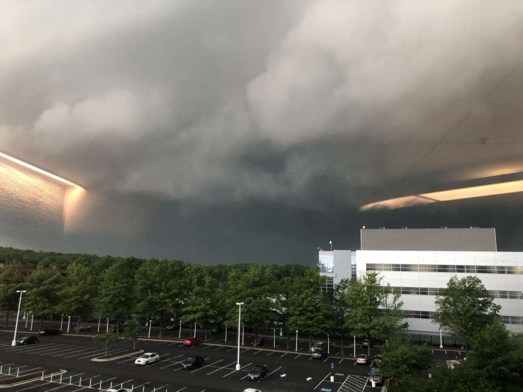
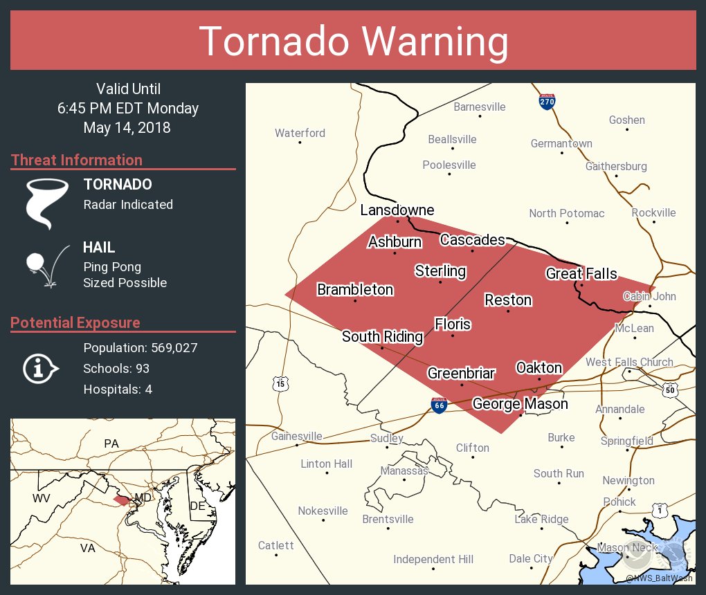
A tornado warning for the area was canceled at 6:45 p.m. today. Penny-size was reported as a rain, hail, thunder, and strong winds swept into the area.
Earlier:
A severe thunderstorm capable of producing a tornado was located near Leesburg.
❗️❗️⚠️ pic.twitter.com/BqFAXYvZPe
— Fairfax County Government 🇺🇸 (@fairfaxcounty) May 14, 2018
Residents should take cover by moving to a basement or an interior room on the lowest floor of a sturdy building, according to the alert.
Here’s more from NWS:
IMPACT…For those in the direct path of a tornado touchdown,
flying debris will be dangerous to those caught without
shelter. Damage to roofs, siding, and windows may occur.
Mobile homes may be damaged or destroyed. Tree damage is
likely.* This dangerous storm will be near…
Lansdowne around 620 PM EDT.
Broadlands and Brambleton around 625 PM EDT.
Arcola around 630 PM EDT.
Ashburn and Countryside around 635 PM EDT.
Dulles International Airport around 640 PM EDT.
Reston, Herndon, Lowes Island, Oakton, Sterling, Chantilly and
Great Falls around 645 PM EDT.Other locations impacted by this tornadic thunderstorm include
Congressional Manor, Belmont, Belleview, Sterling Park, Bradley
Farms, Cabin John and Fairfax Station.
Photos by @Cynthia_Adler, @wdudley2009 and @NWS_BaltWash

A National Weather Service code orange air quality alert has been issued for the Washington Metro region, including Reston.
The alert states that “air pollution concentrations within the region may become unhealthy for sensitive groups.” That includes children, asthma sufferers, the elderly, and those with heart and lung conditions.
Anyone outside of those groups are unlikely to experience any side effects.
For the sensitive groups, however, staying inside and avoiding exertion are the best ways to avoid air pollution effects, according to the alert.
A code orange is not an indication of the worst air quality. The color alert scale ranges from, in order of least to most harmful, green, yellow, orange, red, purple, and maroon.
The AQI, or air quality indicator, ranges from 0-500. Maroon would indicate the highest, most hazardous health concern, with an AQI of 301-500. The alert today (May 2), a code orange, indicates an AQI of 101-150.
Photo courtesy of Ryan Goff
 Freezing rain is expected to hit Reston and surrounding areas beginning this afternoon, according to the National Weather Service.
NWS issued a winter weather advisory that will remain in effect from 3 to 9 p.m. today. Freezing rain or rain that will freeze upon contact with cold surfaces. Sidewalks, roads and bridges are expected to very slippery.
“Even if temperatures rise above freezing, the ground and other surfaces are still extremely cold due to the recent Arctic blast. This increases the likelihood of a glaze of ice on surfaces,” according to the advisory.
All Reston Community Center programs have been cancelled. Fairfax County Public Schools closed today because of the possibility of freezing rain.
A Winter Weather Advisory remains in effect today for a light wintry mix expected to impact this evenings commute. Latest: https://t.co/ZOlvESgJ2H. #WVwx #MDwx #VAwx #DCwx pic.twitter.com/0gpbQWOvmX
— NWS Baltimore-Washington (@NWS_BaltWash) January 8, 2018