
First it snowed. Then the freezing rain fell. Now it is just rain on top of ice — at least until later today.
Tuesday morning’s weather has made for slick sidewalks and traffic backups, but forecasters say temperatures should rise quickly and make things slushy — but not dangerous — in the next few hours. Highs should be near 50 by mid-day.
Meanwhile, Fairfax County Public Schools are closed. Fairfax County Government is open. Metro is on its regular weekday service plan, but delays are being reported on Blue, Orange and Silver lines.
Fairfax County is also under a flood watch today, with the greatest flood risk Tuesday afternoon and evening, according to the National Weather Service. A flood watch means there is potential for flooding.
Let us know what you see out there on your commute this morning.
Ice on trees in Reston Feb. 16/Credit: Douglas H. Errett via Twitter
 Update, 2 p.m. Friday: Fairfax County Public Schools have canceled all evening activities due to inclement weather.
A little bit of snow is likely heading here this evening. It’s not much, but it may be just enough to impact evening rush hour.
The Capital Weather Gang says about a half-inch of snow is expected to move through Northern Virginia about 6 p.m. But combined with very cold temperatures, that could make for icy roads and backed-up traffic, similar to what we saw on Jan. 20.
On Jan. 20, an early evening dusting turned short commutes into hours-long treks within Fairfax County and from DC to Northern Virginia.
The Virginia Department of Transportation says it will have 1,150 trucks deployed to continually treat roads by early afternoon. Crews began treating roads in advance yesterday and are finishing mid-day today, said VDOT.
Read more on the Capital Weather Gang and from the National Weather Service.
file photo
 Fairfax County officials say they do not have an explanation about what went wrong on area roads when an inch or so of snow fell during Wednesday night’s rush hour.
People reported being stuck in their cars for hours as they tried to get home. Twenty-minute commutes turned into two-hour ordeals all around the Beltway.
The Virginia Department of Transportation (VDOT), and not the county, is responsible for treating most area roads.
Since VDOT — as well as Northern Virginia residents — have had about five days of preparation and warning about the storm expected to begin Friday afternoon, road treatment should be much more effective than on Wednesday, officials said.
“Do they [VDOT] need to do better? Absolutely,” Fairfax County Board of Supervisors Chair Sharon Bulova said at a press conference Thursday afternoon. Read More

The National Weather Service says its Blizzard Watch issued yesterday will become a Blizzard Warning beginning Friday afternoon.
The Blizzard Warning for Reston, Northern Virginia and the Washington, DC area goes into effect Friday at 3 p.m. and will remain in effect through 6 a.m. Sunday, the NWS said.
A Blizzard Warning means severe winter weather conditions are expected or occurring. There will be falling and blowing snow with strong winds and poor visibility, including whiteout conditions, the NWS says.
The forecast for the Reston area is 24 to 30 inches of snow. Read More
 Several adjustments are already being made in advance of the expected snowstorm in Reston Friday and Saturday. The National Weather Service has issued a Blizzard Watch for a storm expected to dump more than a foot of snow here.
South Lakes High School’s basketball games against Langley have been moved from Friday to Thursday, Jan. 21.
Girls will play at home at 7:15 p.m. Boys will play at Langley at 7:15 p.m. Freshman will play at 4:30 p.m.; Junior Varsity at 5:30 p.m.
The Reston Camp Expo, slated for this Saturday at Reston Community Center at Hunters Woods has been moved to Saturday, Jan. 30 at RCC-HW from 9 a.m. to 1 p.m.
The camp expo is an opportunity for families to learn about the many summer opportunities in Reston.
Saturday is also an SAT date at Herndon High School. If Fairfax County Public School activities are canceled on Saturday, then the SAT will also be canceled, College Board officials said.
Students registered to take the test should monitor FCPS updates.
If schools remain open and a student is unable to get to the testing location, the student should call SAT Customer Services at (866) 756-7346 to reschedule.
In the event of a cancellation on Saturday, the makeup date is Saturday, Feb. 20. Students will need to contact their test site to confirm administration of the SAT on the makeup date, the College Board says.
Know of any other postponements or cancellations? Tell us in the comments. Reston Now will also keep you updated with more closings as they occur.
 It’s been a mild winter so far, with barely a few flakes falling in Reston.
That could change this weekend.
It’s four days away, but some forecasters are saying expected snowfall this weekend could be a major storm.
Local TV stations were at a grocery and hardware story Monday night — four days away from said snowfall — already interviewing people who were preparing for the event by buying the usual ice melter and bread.
Does anyone ever take this info seriously anymore? Yes, it’s January. It snows here. But the Washington area seems to have forgotten the different between a forecast of four inches and one of 24 inches. (By the way, they are calling for somewhere in the middle…or they can’t even say this far out).
Bottom line: It will likely snow Friday and Saturday. Here is what the Capital Weather Gang says. Here is info from The Weather Channel.
Whether the storm is brutal or a bust, we will keep you posted on how it will affect Reston.
Snow in Reston/file photo
 Tuesday’s commute home could be kind of slippery. Snow showers — the first of the season — are expected to hit about 4 p.m., followed by a steep drop in temperatures.
Here is the latest (as of about 2 p.m.) from the National Weather Service:
…SNOW SHOWERS AND STRONG WINDS EXPECTED TO IMPACT RUSH HOUR THIS EVENING…
A STRONG COLD FRONT WILL CROSS THE REGION THIS EVENING DURING RUSH HOUR. THE FRONT WILL BE ACCOMPANIED BY SCATTERED SNOW SHOWERS AND STRONG GUSTY WINDS. THE SNOW SHOWERS WILL START TO MOVE INTO THE METRO AREA BY 4 PM AND SHOULD CLEAR THE REGION BY 8 PM.
THE SNOW SHOWERS MAY BE LOCALLY HEAVY AND COULD DROP A QUICK COATING OF SNOW IN SOME AREAS. WHILE ROAD TEMPERATURES ARE WARM AT PRESENT…GUSTY WINDS AND COLDER AIR MOVING INTO THE AREA MAY RESULT IN PATCHES OF ICE ON UNTREATED ROADWAYS THIS EVENING. THE GUSTY WINDS MAY ALSO REACH 50 MPH WHICH COULD CAUSE SPOTTY MINOR DAMAGE.
EVENING COMMUTERS SHOULD USE EXTRA CAUTION AND TAKE THEIR TIME. VISIBILITY COULD DROP RAPIDLY FOR A BRIEF PERIOD DURING HEAVIER SNOW SHOWERS…AND ROADS WHICH APPEAR WET LATER THIS EVENING COULD IN FACT BE ICY.
file photo
 There will be no dashing through the snow this weekend. No sleigh bells or Jack Frost, either.
There may, however, be some driving with the top down to do your Christmas shopping.
Weather forecasters are predicting highs of nearly 70 degrees — more than 20 degrees above normal — for Saturday and Sunday.
Here is what the Capital Weather Gang is saying:
Saturday is a delight from start to finish. There should be plenty of sun with some occasional clouds passing by. Breezes start to pick up from the southwest and help push highs to mid-to-upper 60s. The sunset comes much too early but with readings still in the 60s in the evening it is hard to find fault. Clouds begin to build in overnight. Lows only fall to the upper 40s to lower 50s.
Skies on Sunday have a veil of high clouds. A warm wind from the south provides a good chance that some areas could hit record highs as temperatures peak in the mid-60s to around 70. Clouds are likely to increase in the evening as a storm in the Mississippi Valley starts to fire up and head our way. Overnight lows only drop to the low-to-mid 50s.
Could this mean a mild winter in Northern Virginia? The Capital Weather gang says expect a “run-of-the-mill” season with a few snow events.
But for now, enjoy the last taste of fall.

Get ready for a rainy weekend as a front that could cause up to a half a foot of rain heads towards Reston, only to possibly be followed soon after by Hurricane Joaquin.
Here is what you need to know:
The National Weather Service has issued a Flash Flood Watch from Friday morning to Saturday evening. Rain will increase in intensity across the area Friday into Saturday, with two to four inches expected, with spots seeing higher amounts. Rain could fall over a short period of time on already saturated land.
Virginia Gov. Terry McAuliffe issued a state of emergency late Wednesday afternoon. The Executive Order operates retroactively to Tuesday, when parts of Virginia were deluged with 6 inches of rain.
The state of emergency allows state and local emergency responders to begin to prepare for the effects of rain forecast across the Commonwealth Thursday and Friday, as well as the potential that Hurricane Joaquin will impact Virginia.
“I cannot stress enough the imperative for Virginians to focus on the rainstorms that are headed our way tomorrow and Friday, well before Hurricane Joaquin could potentially impact Virginia,” Governor McAuliffe said in a statement.
“The forecast of up to 10 inches of rain in areas across Virginia could result in floods, power outages and a serious threat to life and property. As we continue to track the path of Hurricane Joaquin, I have instructed the Secretary of Public Safety and Homeland Security to make every preparation for a major event Thursday and Friday.”
The National Weather Service declared Joaquin a hurricane Wednesday morning when it was several hundred miles East-Northeast of the central Bahamas with winds of up to 85 mph. By Wednesday night, Joaquin had strengthened to a Category 3 (120 mph winds).
Said the NWS: “The storm may move closer to the Mid-Atlantic during the next several days. The details of how significantly the storm will impact us will become clearer as the week progresses. If it does impact us, sometime between late Friday through Monday is the most likely time. If the storm does reach the Mid-Atlantic be aware that heavy rain, wind, and tidal flooding will be possible.”
The Capital Weather Gang said on Wednesday “there’s no need to panic, but simply to begin thinking about hurricane and flooding preparedness and remaining tuned to the forecast, as it is likely to evolve substantially over the next 72 hours.”
“Hurricane Joaquin is forecast to come very close to the Mid-Atlantic coast, and possibly move inland, said the Capital Weather Gang. “At the very least, a period of heavy rain is likely. In a worst-case scenario, the region could contend with a dangerous, long-duration flooding event, widespread damaging winds and a significant surge of water up the Chesapeake Bay and Potomac River.”
Some computer models have Joaquin making landfall in North Carolina; other say it will stay off shore.
Some weekend events may be altered due to the storm. Herndon High’s football game at Tuscurora has already been moved from Friday night to tonight. Washington Redskins and DC United officials also say they are monitoring developments that may affect weekend games.
Reston Now will update this story as it develops.
Graphic courtesy National Weather Service
 The National Weather Service has issued a heat advisory for the entire D.C. Metro area from noon to 8 p.m. Monday as temperatures will climb into the high 90s.
With the heat index, it will feel like 109, meteorologists said.
A heat advisory means that a period of high temperatures is expected and the combination of high temperatures and high humidity creates a situation in which heat illnesses are possible, says the NWS.
From the NWS:
* HEAT INDEX VALUES…UP TO 109 DUE TO TEMPERATURES IN THE MID TO UPPER 90S AND DEWPOINTS IN THE LOW TO MID 70S
* IMPACTS…RISK OF HEAT-RELATED ILLNESS FOR THOSE WITHOUT AIR- CONDITIONING OR THOSE OUTDOORS FOR AN EXTENDED PERIOD.
PRECAUTIONARY/PREPAREDNESS ACTIONS…
TAKE EXTRA PRECAUTIONS IF YOU WORK OR SPEND TIME OUTSIDE WHEN POSSIBLE.
RESCHEDULE STRENUOUS ACTIVITIES TO EARLY
MORNING OR EVENING.KNOW THE SIGNS AND SYMPTOMS OF HEAT EXHAUSTION AND HEAT STROKE. WEAR LIGHT WEIGHT AND LOOSE-FITTING CLOTHING WHEN POSSIBLE AND DRINK PLENTY OF WATER.
TO REDUCE RISK DURING OUTDOOR WORK…THE OCCUPATIONAL SAFETY
AND HEALTH ADMINISTRATION RECOMMENDS SCHEDULING FREQUENT REST BREAKS IN SHADED OR AIR CONDITIONED ENVIRONMENTS.ANYONE OVERCOME BY HEAT SHOULD BE MOVED TO A COOL AND SHADED LOCATION. HEAT STROKE IS AN EMERGENCY – CALL 9 1 1.
Photo: Summer sun/Credit: Lee via Flickr
 The National Weather Service has issued a Severe Thunderstorm Watch for Northern Virginia through 11 p.m. Tuesday.
A watch means conditions are favorable for a severe thunderstorm. Heavy rain, strong wind and hail are all possible.
After a day of near-record heat and a heat advisory (which will remain in effect until 7 p.m.), storms are expected to to hit Reston between 4 and 7 p.m., forecasters said.
With the humidity today, the heat index made it feel around 105 degrees outside.
 Tuesday is forecast to be the hottest day of 2015 so far, the National Weather Service says.
A heat advisory for Reston, Northern Virginia and the DC area is in effect from 1 to 7 p.m. as afternoon temperatures may hit 99 degrees. With the heat index, it will feel like 105, so take precautions.
A heat advisory means a period of high temperatures is expected. The combination of high heat and high humidity creates a situation in which heat illnesses are possible, says the NWS.
To avoid head exhaustion and heat stroke:
- If possible, reschedule outdoor strenuous activities to early morning or evening.
- Wear lightweight and loose-fitting clothes.
- Drink plenty of water.
Relief is in sight late in the day, when thunderstorms are expected to roll through Reston, bringing with them slightly lower temperatures for Wednesday.

Updated, 1:15 p.m. Friday).
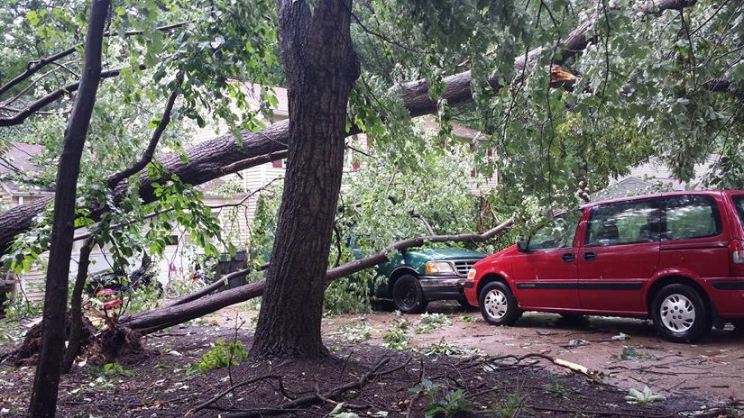
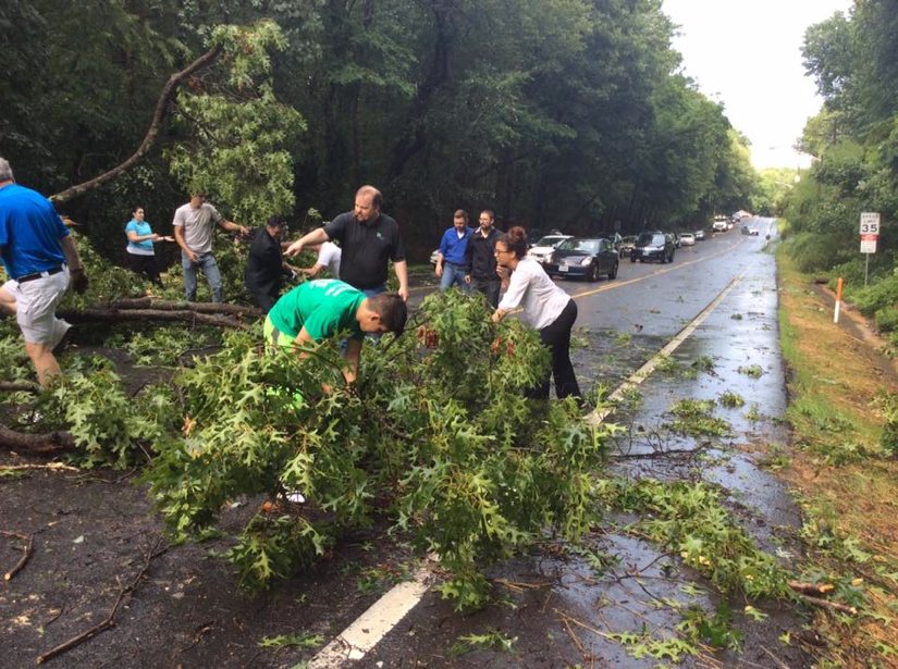
Many residents of South Reston are beginning to clean up this morning after a quick but powerful thunderstorm moved through the area Thursday night, downing trees and power lines.
The storm may have included a microburst, meteorologists said. A microburst is a very localized column of sinking air within a thunderstorm, says the National Weather Service. It can last a few seconds or a few minutes, but has the power to knock over large trees.
The Capital Weather Gang has some detailed information on how Thursday’s microburst formed over Western Fairfax County.
Fox Mill Road, which was closed at Fox View Road overnight dus to a downed tree and power lines, is reopened.
Reston Association says it is working in conjunction with the Virginia Department of Transportation to remove debris from the storm. VDOT is responsible for clearing and ensuring the safety of state streets. Secondary cleanup of the tree debris will be completed after all VDOT roadways are clear and safe, says RA.
Says RA: “Priorities for clearing hazards will be placed on compromised trees that could potentially cause harm to a person and/or damage property or infrastructure.”
The RA Central Services Facility team will also be clearing the RA paths of debris this morning.
Dominion Virginia Power said more than 2,500 Reston-area homes lost power last night. Fewer than 1,000 countywide are still without power this morning.
Back-to-back thunderstorms that ripped through Reston late Thursday afternoon left behind noticeable damage.
The Capital Weather Gang said the strong winds may have been a microburst.
The high winds knocked over many trees, and power is out in more than 2,500 Reston-area homes, said Dominion Virginia Power.
Here is what you need to know:
Many of the power outages appear to be along Lawyers and Glade Roads.
A tree fell on a power pole on Fox Mill Road near Fox View Way, knocking out power. Fox Mill Road was closed as of 6:30 p.m.
Reston Parkway Southbound is very backed up due to traffic lights not working. Fairfax County Police are on the scene directing traffic.
A downed tree is blocking Glade Drive near Millennium Lane.
So far, there are no reports of injuries from Fairfax County Fire and Rescue.
If you have to be somewhere, please check road conditions before you go.
This story will be updated if there is any additional info.
 Updated, 3:30 p.m. Monday) The National Weather Service has issued a tornado watch until 10 p.m. for Reston, Northern Virginia and the entire Washington, D.C. area.
An isolated tornado or two could develop through this evening, but damaging winds and hail are more likely hazards, the NWS says.
From the NWS:
PRIMARY THREATS INCLUDE...
     A COUPLE TORNADOES POSSIBLE
     SCATTERED LARGE HAIL AND ISOLATED VERY LARGE HAIL EVENTS TO 2
       INCHES IN DIAMETER POSSIBLE
     SCATTERED DAMAGING WIND GUSTS TO 70 MPH POSSIBLE

   SUMMARY...THUNDERSTORMS ARE EXPECTED TO DEVELOP OVER NORTHERN VA AND
   WESTERN MD THIS AFTERNOON...TRACKING ACROSS THE WATCH AREA.
   DAMAGING WINDS AND HAIL ARE THE MAIN THREATS.  HOWEVER...BACKED LOW
   LEVEL WINDS NEAR A WARM FRONT MAY BE SUFFICIENT TO ENHANCE THE RISK
   OF ISOLATED TORNADOES OVER NORTHERN PARTS OF THE WATCH.

   THE TORNADO WATCH AREA IS APPROXIMATELY ALONG AND 90 STATUTE
   MILES EAST AND WEST OF A LINE FROM 30 MILES EAST SOUTHEAST OF
   CHARLOTTESVILLE VIRGINIA TO 25 MILES NORTH OF HARRISBURG
   PENNSYLVANIA.  FOR A COMPLETE DEPICTION OF THE WATCH SEE THE
   ASSOCIATED WATCH OUTLINE UPDATE (WOUS64 KWNS WOU0).

   PRECAUTIONARY/PREPAREDNESS ACTIONS...

   REMEMBER...A TORNADO WATCH MEANS CONDITIONS ARE FAVORABLE FOR
   TORNADOES AND SEVERE THUNDERSTORMS IN AND CLOSE TO THE WATCH
   AREA. PERSONS IN THESE AREAS SHOULD BE ON THE LOOKOUT FOR
   THREATENING WEATHER CONDITIONS AND LISTEN FOR LATER STATEMENTS
   AND POSSIBLE WARNINGS.
Original story: The National Weather Service has issued a Severe Weather Outlook for Northern Virginia Monday afternoon and evening.
The NWS says there could be severe storms that feature hail and there may be isolated tornadoes.
As of Monday at noon, the forecast said there was an enhances storm risk. A 2 percent chance of a tornado within 25 miles, and a 30 percent chance of hail and damaging winds more than 55 miles per hour.
The risk could increase later on Monday, says the Capital Weather Gang.
The storm risk will begin at 5 p.m. and run until 10 p.m. Monday.
file photo