")
It took until March 14 for the first and potentially only snowstorm of the season to hit the Reston area, and its results are underwhelming for many who have been patiently waiting.
Monday morning, we asked readers to predict how much snow would fall during this weather event. More than 43 percent of respondents to our unscientific poll said we would see 4-8 inches. Another 20 percent called for 8-12 inches, while about 5 percent wanted a foot or more.
The National Weather Service’s official snowfall readings for Fairfax County this morning report between 1 and 3.5 inches of snow, with the highest numbers in the Vienna area.

At least one Facebook reader took issue with terminology that was being used to describe the storm.
“‘Significant snow has fallen’ — every picture is of ice and slush,” Brenda Leong wrote on our Facebook page. “I suppose an inch or so is significant compared to the nothing all winter — but it’s certainly not the 5 to 7 to 12+ we were led to expect.”
Not everyone is unhappy with the relatively small amount of snow, though, as Douglas Errett shared with us on Twitter.
https://twitter.com/MrErrett/status/841653419970564097
Dominion Power reports just a handful of power outages, affecting 189 customers as of 10 a.m., in the county.
The National Weather Service says flurries are possible throughout the rest of the day, but conditions as a whole are on the rise.
Weather conditions have started to improve across our area. Snow flurries possible for the rest of the day. #DCwx #MDwx #VAwx #WVwx pic.twitter.com/XgSmcca0OQ
— NWS Baltimore-Washington (@NWS_BaltWash) March 14, 2017
VDOT encourages drivers to stay off the roads to allow plows to finish their work. Fairfax County Fire and Rescue reminds residents to use moderation when cleaning up heavy, wet snow — if they have any to clean up.
Take It Slow When Shoveling Snow. Heavy snow can be a health risk. More: https://t.co/j4xBGAlPTE #snow pic.twitter.com/CaUOhSyaz9
— Fairfax County Fire/Rescue (@ffxfirerescue) March 14, 2017
Photo of Reston Parkway courtesy Karen Eldridge on Facebook
Measurable snow has fallen for the first time this year, and social media users are sharing wintry scenes from around the area.
https://twitter.com/WFOcom/status/841616431087276034
Over two hours of this in Herndon, @capitalweather @TerpWeather @TenaciousTopper @_EllenBryan #SnowDay9 #PialaSnow pic.twitter.com/IjmzkDnCWx
— Chris Mc (@Vaphilly624) March 14, 2017
Sleeting at #FlyDulles while the snow team works on the center runway complex pic.twitter.com/mHrygAVZqY
— Dulles Airport (IAD) (@Dulles_Airport) March 14, 2017
Snow plows clearing the roads in #Herndon where @David_Culver is checking out the conditions! pic.twitter.com/0CJkPXdsNW
— Sam Nassau (@samuelnas) March 14, 2017
https://twitter.com/Fred_Krazeise/status/841607509458731008
We're in Reston. This sidewalk was cleared just about 30 minutes ago. Already covered again. The snow is coming down quick. #snowday9 @wusa9 pic.twitter.com/HAXGEBCNN7
— John Henry (@JohnHenryDC) March 14, 2017
Share your photos with us at [email protected] and we may use them later today.

The Virginia Department of Transportation is telling residents that if they don’t have to go out today, don’t.
Snow, sleet and freezing rain has fallen in Reston and the surrounding area, and drivers are being advised to stay off the roads. VDOT warns that anyone who must travel should reduce speeds, use extreme caution and be alert to icy and inclement conditions. Road temperatures are expected to remain below freezing all day, with potential for continued refreeze.
To see current road conditions and snowplow activity, visit www.vdotplows.org.
Simulation shows wintry mix continuing next few hours, before precip ends as snow late morning to early afternoon: https://t.co/wuM0TkJR4y pic.twitter.com/oBaVmQ5cma
— Capital Weather Gang (@capitalweather) March 14, 2017
Area closings, cancellations and other re-schedulings include:
- Fairfax County Public Schools are closed.
- Reston Association offices will open with a 2-hour delay. RA evening meetings have been called off.
- All Reston Community Center programs are canceled today. The pool will open at 9 a.m.
- The Lake House will be open at 9:30 a.m. for the School Day Off program.
- All School Age Child Care (SACC) centers in the county are closed.
- The Office of Personnel Management says federal employees are working on a 3-hour delay today. Employees have the option for unscheduled leave or unscheduled telework.
- Metrorail is operating on a Saturday schedule. Metrobus services are working under the Moderate Snow Plan.
- Fairfax Connector bus service will operate on a Saturday schedule. Check www.fairfaxconnector.com for the current operating status.
- There will be no county trash or recycling pickup today.
- MVB Bank (1801 Old Reston Ave.) will open on a 3-hour delay.
- The Capital Bikeshare system will remain open today; however, there will be no rebalancing of bikes.
- For information about FASTRAN, call 703-222-9764, TTY 711 or visit www.fairfaxcounty.gov/ncs/
fastran.htm. - Fairfax County government offices are open. However, employees have been granted unscheduled leave. Emergency service personnel should report as scheduled.
- Today’s Fairfax County Board of Supervisors meeting will start at 1 p.m.
- View the county’s public meetings calendar for any potential cancellations of public meetings of Fairfax County government Boards, Authorities or Commissions.
- The Fairfax County Circuit Court, General District Court and Juvenile and Domestic Relations District Court have not yet made a decision on operating status.
If you have a closing or cancellation to add to our list, please email [email protected]. Use the same address to send us any snow day photos or other information you would like us to share with the community.
Photo via @RenaeDitmer on Twitter

After a snowless winter, it looks like Reston will finally be hit.
Forecasters are predicting several inches of snow for the area, with an outside chance of a foot or more, beginning tonight and continuing into Tuesday.
We're lowering the snow forecast a little in the immediate area. Remains a (complicated!) significant snowstorm. https://t.co/sVDps838I1 pic.twitter.com/DuzOHrDUiW
— Capital Weather Gang (@capitalweather) March 13, 2017
The National Weather Service has placed an area including Reston under a winter storm warning that is scheduled to begin at 7 p.m. Monday and last through 2 p.m. Tuesday. According to the alert, their official predictions include the following:
* PRECIPITATION TYPE…Snow…possibly mixed with sleet at times
Monday night.* ACCUMULATIONS…Snow accumulation of 6 to 10 inches.
* TIMING…Snow will overspread the area Monday evening and
persist through Tuesday morning.* IMPACTS…The heavy snow will create difficult travel
conditions and may produce scattered power outages.* WINDS…Northeast 5 to 15 mph with gusts up to 30 mph.
* TEMPERATURES…In the lower 30s.
Simulated satellite of what's about to happen the next 2 days #noreaster #blizzard #Stella pic.twitter.com/PjFmiJ3KPQ
— Stu Ostro (@StuOstro) March 13, 2017
In preparation for the storm, the Virginia Department of Transportation began pre-treating roads Sunday. The department is encouraging drivers to adjust their schedules to be off roads before the evening rush hour Monday and overnight.
“This will help avoid being stuck on the roads when the storm begins, and to allow crews room to work more safely and efficiently,” VDOT said in a release.
In addition, VDOT asks that vehicles be parked in driveways, or that communities coordinate to all park on the same side of the road, to allow a larger path when plows begin to focus on neighborhood streets.
NEW: National Weather Service reduced their forecast from 6-8" to 4-6" in Washington, DC. We will release a new map following PM models! pic.twitter.com/h6Z1I20Mkn
— Mike Thomas (@MikeTFox5) March 13, 2017
Such a significant snowfall would also have an impact on public transportation.
Metro will suspend its MetroAccess paratransit services at 4 p.m. today, and they will remain out of service through Tuesday. In addition, Metrobus service changes are possible and will be announced based on weather conditions and forecast.
Fairfax Connector is reminding users that service may be reduced, modified or suspended, on a route-by-route basis or systemwide. Riders are encouraged to monitor schedules online or call customer service (703-339-7200) for updates.
Photo via Virginia Department of Transportation on Twitter (@VaDOTNOVA)

Is It Going to Snow This Weekend or Not? — A few snowflakes are possible this weekend, but forecasts seem to indicate a growing chance that a storm previously predicted to hit us will miss the area. [Capital Weather Gang]
RA Focusing on Future of Golf Courses — In the latest “Reston Today” dispatch, Reston Association land-use attorney John McBride breaks down what’s going on with potential threats to Reston National Golf Course and Hidden Creek Country Club. [Reston Association/YouTube]
Seuss To Be Celebrated at Library — Children ages 4 and up are invited to Reston Regional Libary on Monday at 4:30 p.m. for a celebration of the works of Dr. Seuss. Steve Somers will present the stories at the event, co-sponsored by Friends of Reston Regional Library. [Reston Regional Library]
Reston Company Named to CNBC ‘Upstart’ List — Reston-based Cloudistics gives its customers “all the simplicity, elasticity and consumption characteristics of the public cloud, with the predictability of performance, cost and data governance that a private cloud offers.” Its work has been honored by recognition on CNBC’s list of 25 startups that are breaking industry barriers. [CNBC]

The National Weather Service in Sterling has issued a severe thunderstorm warning for the area until 1:45 p.m.
From the bulletin:
* At 104 PM EST, severe thunderstorms were located along a line
extending from Broadlands to near Haymarket to 9 miles east of
Orange, moving east at 50 mph.HAZARD…60 mph wind gusts.
SOURCE…Radar indicated.
IMPACT…Damaging winds will cause some trees and large branches
to fall. This could injure those outdoors, as well as
damage homes and vehicles. Roadways may become blocked by
downed trees. Localized power outages are possible.
Unsecured light objects may become projectiles.* Locations impacted include…
Arlington, Alexandria, Stafford, Centreville, Waldorf, Dale City,
Rockville, Bethesda, Reston, Bowie, Leesburg, Annandale, Clinton,
Springfield, College Park, Fredericksburg, South Riding, Fort
Washington, Herndon and Greenbelt.PRECAUTIONARY/PREPAREDNESS ACTIONS…
Get indoors to protect yourself from wind and lightning. Trees around
you may be downed from damaging winds, so if you are near large
trees, move to an interior room on the lowest floor. Don’t drive
underneath trees or in wooded areas until the threat has passed.
Radar map via National Weather Service

Strong Storms Possible Later Today — Temperatures in the 70s are again predicted for this afternoon. However, showers and thunderstorms are possible into the evening, with damaging winds and large hail also possible. [Capital Weather Gang]
More Craft Beer on the Way? — New zoning regulations approved Tuesday by the Fairfax County Board of Supervisors may open the door for more small breweries in Reston. There are currently seven licensed craft breweries in the county. [Fairfax County]
Rider: Metro Worst System He’s Used — David Ballard, of Reston, compares his experience on the Metro to public transportation systems in Denver, Salt Lake City, Portland, Dallas and Mexico City. He says the DC system not only is “by far” worse than the others, it’s more expensive. [Washington Post]
Metro Ridership Down Dramatically — At the Wiehle-Reston East station, ridership was down 13.4 percent in the last quarter of 2016. Ridership on the Silver Line as a whole was down 9 percent. [WTOP]
Summertime, are you here already?
The temperature pushed the high end of the 70s Thursday afternoon, the fourth day in February during which the mercury has broken into those figures.
Today will be the 4th time this month (February, in case you forgot) in the 70s. 74 is average for May 10th #NBC4DC pic.twitter.com/rSIVbOEtRo
— Chuck Bell (@ChuckBell4) February 23, 2017
At nearby Dulles International Airport, the thermometer hit 76 degrees at 2 p.m. — breaking the previous Feb. 23 record, set in 1985, by 3 degrees. It is the second-highest February temperature ever recorded at the airport, since records began in 1963.
Dulles Airport soars to 76 degrees, crushing previous record high: https://t.co/2Wxwu6JQ4p
— Capital Weather Gang (@capitalweather) February 23, 2017
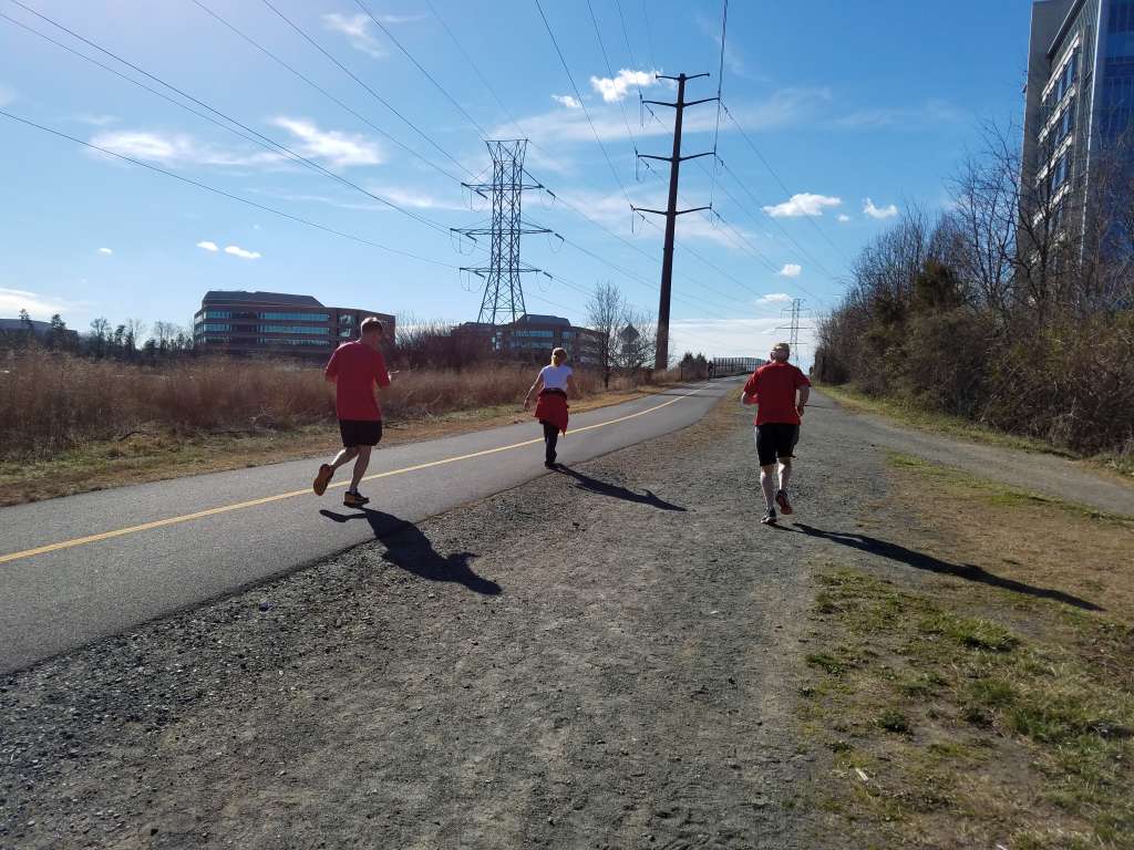
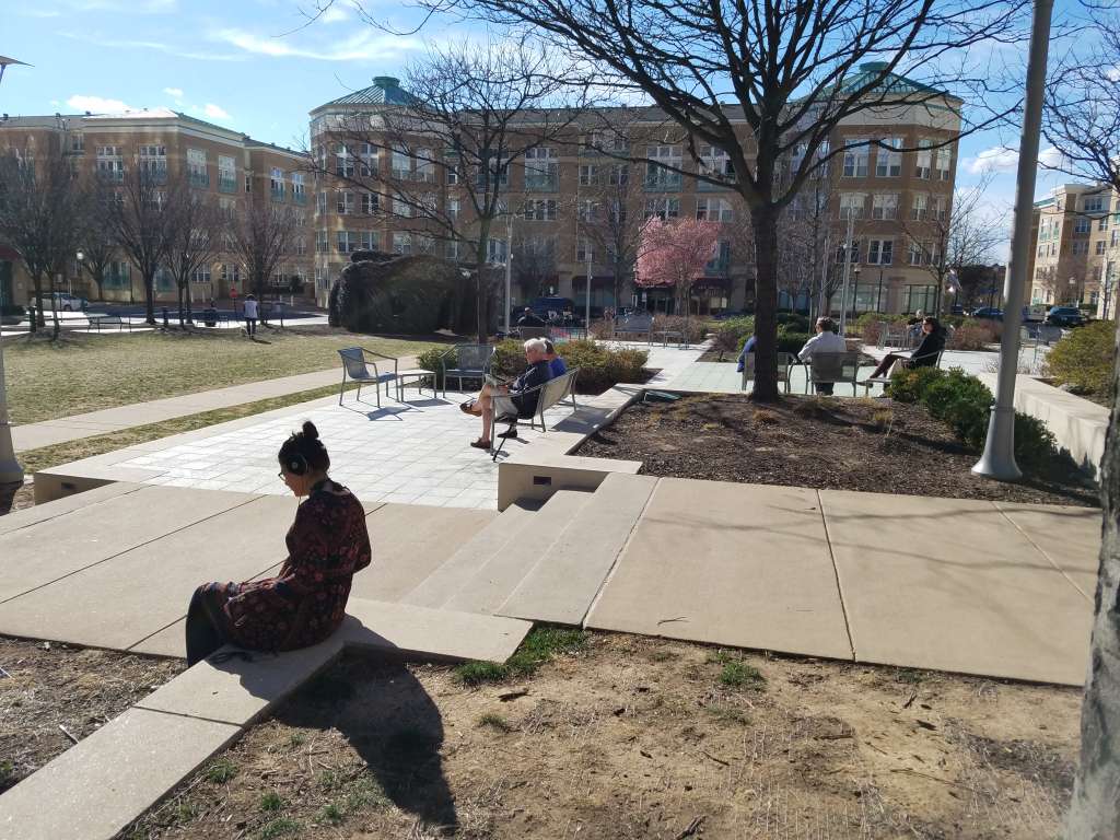
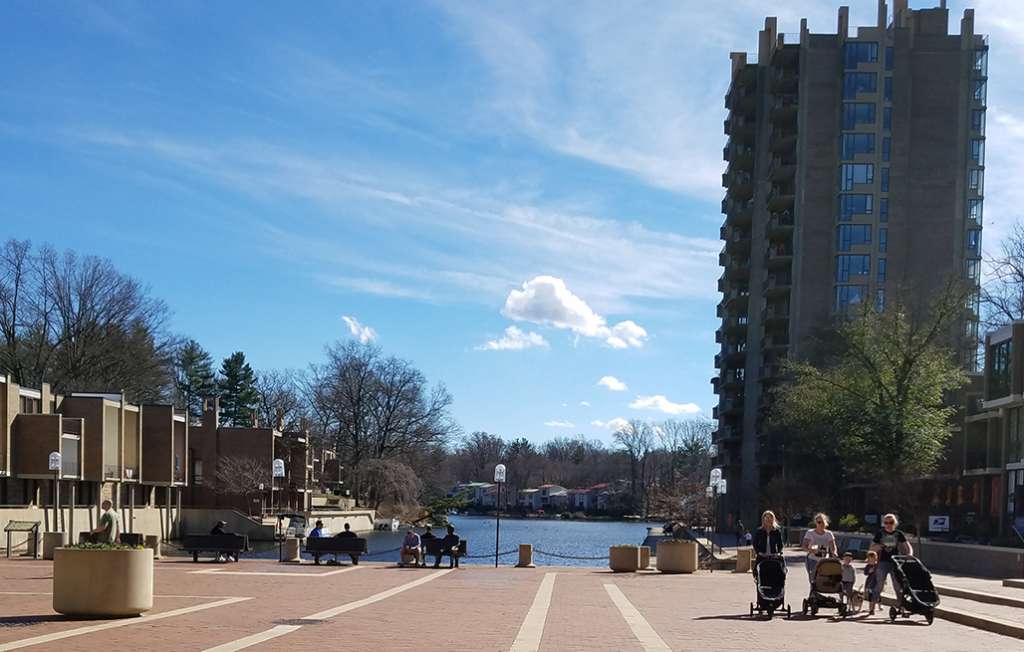
Around Reston, residents could be seen enjoying the unseasonable warmth as they have been for the past several days — biking, running on trails, gathering around Lake Anne, working outdoors and altogether just soaking in a February unlike others in recent memory.
Doors are open and the patio is rockin'! Keep the 74º weather coming. @RestonTwnCenter @RestonChamber #RestonTownCenter pic.twitter.com/g48X26jNva
— Mon Ami Gabi (@MonAmiReston) February 23, 2017
The forecast for the next few days shows high temperatures dropping to the 50s Sunday and Monday, only to go back up mid-week as February turns to March.
Looks like Feb will end with 23 of 28 days above avg. @DMVFollowers have saved tons of $ on heating bills. #NBC4DC pic.twitter.com/WTlPqgBc4c
— Chuck Bell (@ChuckBell4) February 23, 2017
So, what do you think about this weather? Would you like to see it continue?
 High winds that have been blowing hard through Reston today are expected to continue into the early evening.
The National Weather Service in Sterling has issued a wind advisory for the entire region that is scheduled to be in effect until 6 p.m.:
* WINDS…Northwest 20 to 25 mph with gusts around 45 mph.
* IMPACTS…Gusty winds will blow around unsecured objects. Tree
limbs could be blown down and a few power outages may result.PRECAUTIONARY/PREPAREDNESS ACTIONS…
A Wind Advisory means that winds of 45 to 55 mph are expected.
Winds this strong can make driving difficult…especially for
high profile vehicles.
When combined with today’s temperatures in the 30s, the winds are going to make bundling up important.
A wind advisory for the areas in tan until 6PM this evening. Wind chills in the teens and 20s, bundle up! pic.twitter.com/PCw4bVYTK4
— Amelia Draper (@amelia_draper) February 9, 2017

Snow Forecast Disappoints — Snow that was predicted to fall overnight didn’t amount to much of anything in Fairfax County, but it will remain windy and cold today. Warmth is expected to return soon, with 60s or even low 70s possible again Sunday. [Capital Weather Gang]
Three Divas Readying for Upcoming Show — Reston’s three divas (Beverly Cosham, Menda Ahart and Felicia Kessel-Crawley) will perform Friday, Feb. 17 at Reston Community Center, Lake Anne. Though the concert is free, seating is limited and reservations are encouraged. [Reston Museum]
Notable Death: Ralph Edward Groening — Groening, a longtime Reston resident, died earlier this week at the age of 97. Groening was a veteran of World War II and the Korean War, and worked for the U.S. Department of Agriculture for several decades. [Reston Patch]

The National Weather Service has once again placed an area including Fairfax County under a wind advisory. It is scheduled to be in effect until 7 p.m. Thursday.
From the NWS statement:
* WINDS…WEST 20 TO 30 MPH WITH GUSTS AROUND 50 MPH.
* IMPACTS…STRONG WINDS MAY BLOW DOWN LIMBS…TREES…AND POWER
LINES. SCATTERED POWER OUTAGES ARE POSSIBLE.PRECAUTIONARY/PREPAREDNESS ACTIONS…
A WIND ADVISORY MEANS THAT WINDS OF 45 TO 55 MPH ARE EXPECTED.
WINDS THIS STRONG CAN MAKE DRIVING DIFFICULT…ESPECIALLY FOR
HIGH PROFILE VEHICLES.
Winds quite gusty behind the front! Remain windy at times this afternoon… pic.twitter.com/nhW2ecush0
— Tucker Barnes (@TuckerFox5) January 26, 2017
The advisory was originally issued for areas west of the Metro area, but was later expanded.
Wind Advisory EXPANDED. Strongest winds through early evening. pic.twitter.com/Zgxt7zT9KX
— NWS Baltimore-Washington (@NWS_BaltWash) January 26, 2017
Weather alert map via National Weather Service

Update 3:30 p.m.: According to an alert from the National Weather Service, this wind advisory has been canceled.
It has been extremely windy all day in Reston and the surrounding area, and that isn’t expected to let up until later this evening.
From the National Weather Service:
…WIND ADVISORY NOW IN EFFECT UNTIL 7 PM EST THIS EVENING…
* TIMING…THROUGH EARLY EVENING.
* WINDS…EAST WINDS 25 MPH WITH GUSTS TO 45 MPH.
* IMPACTS…STRONG WINDS MAY BLOW DOWN LIMBS…TREES…AND POWER
LINES. SCATTERED POWER OUTAGES ARE EXPECTED.PRECAUTIONARY/PREPAREDNESS ACTIONS…
A WIND ADVISORY MEANS THAT WINDS OF 45 TO 55 MPH ARE EXPECTED.
WINDS THIS STRONG CAN MAKE DRIVING DIFFICULT…ESPECIALLY FOR
HIGH PROFILE VEHICLES.
Fairfax County Fire and Rescue reports that units were deployed to 21 reports of downed power lines between 6 a.m. and 1 p.m. Monday.
Beware Downed Power Lines. Since 6 am today, & as of 1 pm, we have responded to 21 calls for reports of wires down. https://t.co/IzeqqGy8s5 pic.twitter.com/47KzYDpShO
— Fairfax County Fire/Rescue (@ffxfirerescue) January 23, 2017

It’s January, and it appears the inevitable is about to arrive. Snow is finally ready to hamper our commutes.
Rush-hour drives this evening and Friday morning are likely to get a little dicey thanks to winter weather. The Virginia Department of Transportation says anti-icing action began Wednesday, and the telltale lines are evident on streets and highways throughout the area.
VDOT says more than 1,100 pieces of equipment were being stages on area roadways this afternoon in preparation for the snow’s onset. Crews are expected to treat roads with salt and sand once the snow starts to fall. Workers are scheduled to remain on duty throughout the course of the storm, plowing in areas that see 2 inches of snow or more.
Area forecasters seem to be in agreement that the biggest impact of this weather event will be felt to the north and west of Fairfax County.
Models pretty consistent in predicting dusting south to 1-2" north across DC area tonight. More info: https://t.co/saWmGl5JNk pic.twitter.com/FmWDY8rd5J
— Capital Weather Gang (@capitalweather) January 5, 2017
Coating to 1" around #DC -some isolated spots NW of 2.00". Travel overnight could be difficult. Delays likely Fri AM pic.twitter.com/8G9Maj7TtO
— Lauryn Ricketts (@laurynricketts) January 5, 2017
Stay wx aware today, as the 1st accum. snow this season is expected.Remember even light amts of snow can cause hazardous driving conditions! pic.twitter.com/PlaH8jJrPi
— NWS Baltimore-Washington (@NWS_BaltWash) January 5, 2017
As warned by the National Weather Service in the above tweet, even a small amount of snow can cause a major disruption to driving conditions. VDOT urges drivers to adjust their commutes to account for additional travel time and avoid driving during the storm. In addition, drivers are being asked to:
- Not overdrive conditions
- Reduce speeds and use headlights
- Take it slow on bridges, ramps, overpasses and other potential trouble spots
- Ensure cars are filled with gas and windshield wiper fluid
- Take time to update their cars’ emergency kits
Fairfax County Schools are also closely monitoring the situation, and Thursday evening activities have been canceled.
FCPS Evening Activities Canceled due to forecast freezing road conditions facilities and school grounds will be closed starting at 6:15 p.m
— Fairfax Schools 🌟 (@fcpsnews) January 5, 2017
The school district offers apps and text alerts to keep parents informed about school announcements, including weather-related delays and closings.
 As winter approaches, parents of students in Fairfax County public schools must prepare for one of the biggest disruptions to their weekday routine — snow days.
Fairfax County Public Schools officials will often try to make a decision the night before regarding whether to delay or cancel school. This can happen if snow has already begun to fall or if a majority of national weather forecasters agree inclement weather is likely by morning. In cases when the forecast is uncertain, though, officials may wait until 4:30 a.m. for the most up-to-date conditions.
One way to keep up with the latest school weather announcements is to download the Fairfax County Public Schools (FCPS) app to your smartphone. The FCPS app is available in the iTunes App Store and on Google Play.
Parents can also contact their child’s school to sign up for text-message alerts about inclement weather decisions.
In addition, school officials say that decisions and announcements will be posted to the district’s Facebook and Twitter accounts, and emails will be sent to parents and subscribers of the FCPS “News You Choose” newsletter. Notifications are also posted to Fairfax County’s cable-access station, Channel 21 (Cox, Reston Comcast and Verizon customers), and sent to local print, online, radio and television media outlets.
Thirteen snow days are built into the 2016-17 school calendar. If 13 or fewer school days are canceled due to inclement weather, no make-up days will need to be added onto the end of the year in June, and no days off for holidays or in-service days will need to be canceled.
A 14th day is also allowed, however, as a free day. After the 14th missed day, every other snow day will need to be made up. A 15th snow day, for example, would be made up by canceling the traditional day off after Easter Sunday — which this year would be Monday, April 17.
We may see a bit of snow on the ground in Reston later this week, meteorologists warn, though the forecast remains in flux.
Late Thursday night into early Friday morning, the forecasters say there is a chance we could experience a coating of up to an inch. There is a higher probability for snowfall between late Friday night and Sunday morning, the Capital Weather Gang says, but the prognosticators believe that snow could miss the local area and hit more to the southeast.
More information about school make-up days can be found on the FCPS website.
https://www.youtube.com/watch?v=zYK92jU2xiA
Video by Fairfax County Public Schools, via YouTube
 To put Reston’s holiday weather forecast in musical terms, the chances are pretty low for a “white Christmas” this year, but hopefully the day will turn out “merry and [at least somewhat] bright.”
Temperatures likely will reach the upper 40s Sunday in Reston, with some peeks of the sun, according to Weather.com.
Christmas Eve is more likely to be wet, though, with a 40 percent chance of rain in the morning. But with the high and low temperatures expected to stay above freezing (47 and 36 degrees, respectively), rain probably won’t turn to freezing rain or snow. The chance of precipitation goes down to only around 10 percent by Christmas morning.
During the past 25 years, the chances of Northern Virginia seeing a white Christmas on any given year have stayed around 25 percent, according to the National Oceanic and Atmospheric Administration. In fact, the only areas of the U.S. where chances are 50 percent or above are in “the mountainous West, northern New England and the far northern tier,” NOAA says.
Reston and the greater D.C. area have had a white Christmas less than 10 times in the past 127 years, according to Reston Patch and DCist. Snow was last on the ground on Christmas in 2009, after the “Snowpocalypse” hit the area.