")
Updated at 2 p.m. — Reston Association has closed all of its pools for the remainder of the day “due to “due to the current and continued threat of hazardous weather.”
Updated at 12:10 p.m. — A Tornado Watch has been issued for the D.C. area, including Fairfax County, until 7 p.m.
Updated at 11:30 a.m. — All activities scheduled to take place in Fairfax County Public Schools this afternoon and evening have been canceled due to the anticipated inclement weather.
Updated at 10:25 a.m. — All of the closed roads in Reston have reopened to traffic, except for the Browns Mill, Beach Mill, and Leigh Mill closures listed below, according to a 10:13 a.m. update from the Fairfax County Police Department.
Earlier: Several roads in Reston have been closed after a thunderstorm courtesy of Tropical Depression Ida passed through Fairfax County overnight.
“We are expecting several inches of rain today from the remnants of Hurricane Ida, picking up in intensity in the early afternoon until around midnight,” Fairfax County said in a post on its emergency information blog. “We have already experienced an early morning storm that has led to power outages, swift water rescues and numerous road closures due to downed trees and flooded roads.”
Road closures due to flooding and downed trees have been reported throughout the county, but as of 8:30 a.m., they have been particularly concentrated in the Reston District Station area, according to the Fairfax County Police Department:
Reston District Station
Browns Mill Rd and Pennycress Ln, closed due to down tree
Beach Mill Rd and Clubview Dr, closed due to downed tree
Hunter Mill Rd and Cedar Pond Dr, closed due to flooding
500 bock of River Bend Rd, closed due to flooding
1100 block of Springvale Rd, closed due to flooding
Leigh Mill Rd and Kelso Rd, closed due to flooding
Walker Rd and Murphy Dr, closed due to downed tree
Hunter Mill Rd and Cedar Pond Dr, closed due to flooding
With more rain expected to fall today, the National Weather Service has extended a Flood Warning for northwestern Fairfax County until 11:30 a.m., citing Reston, Herndon, and Great Falls among the areas that could experience flooding.
“At 8:20 a.m. EDT, stream gauge reports indicated water levels continue to rise across the area. Flooding is ongoing,” the NWS said in its alert.
A Flash Flood Watch is also now in effect for much of the D.C. region, including Fairfax County. It is currently set to last through tomorrow (Thursday) morning:
* A round of heavy thunderstorms early this morning may result in localized flash flooding, especially in the Washington and Baltimore Metropolitan Areas. Additional thunderstorms with heavy rainfall are expected across the area this afternoon and evening. Rainfall amounts of 2 to 4 inches are expected, with localized amounts up to 6 inches possible.
* This amount of heavy rainfall will not only result in the potential for considerable flash flooding of creeks, small streams, and urban areas, but also the potential for river flooding on the main stem rivers.
The Fairfax County Fire and Rescue Department is urging people to avoid driving through flooded or closed roadways, noting that stalled and trapped cars put the driver, passengers, and first responders in unnecessary danger.
“By now, many drivers across Fairfax County know which roads traditionally flood,” the department wrote in a blog post. “FCFRD asks that if you need to be on the roadways today that you stay informed and plan alternate routes around flooded roadways. Our firefighters and paramedics do not want to meet you by (a preventable) ‘accident’!”
A lot of rain throughout today. Several flooded roadways already this morning. PLEASE, do NOT attempt to drive, or walk, through flooded roadways! #TurnAroundDontDrown! Stay weather aware throughout the day! Plan alternate routes! #weather #traffic #FCFRD pic.twitter.com/SmZWO7bvoc
— Fairfax County Fire/Rescue (@ffxfirerescue) September 1, 2021
")
A Flash Flood Watch has been issued for the D.C. area, including Fairfax County.
The alert will take effect at 1 p.m. and is currently set to expire at 11 p.m., as the National Weather Service says “numerous showers and thunderstorms” are expected to pass through the region this afternoon and evening.
While just up to an inch of rain is projected to fall on average, the thunderstorms could bring heavy rainfall within a short period of time to localized areas, potentially leading streams and creeks to flood.
Here is the full NWS alert:
…FLASH FLOOD WATCH IN EFFECT FROM 1 PM EDT THIS AFTERNOON THROUGH
THIS EVENING…The National Weather Service in Sterling Virginia has issued a
* Flash Flood Watch for portions of DC, central Maryland and northern Virginia, including the following areas: in DC, District of Columbia. In central Maryland, Central and Southeast Howard, Central and Southeast Montgomery and Prince Georges. In northern Virginia, Arlington/Falls Church/Alexandria and Fairfax.
* From 1 PM EDT this afternoon through this evening.
* Numerous showers and thunderstorms are expected this afternoon and evening. Average rainfall amounts are expected to be between one half to one inch. However, thunderstorms will be capable of
producing very heavy rainfall rates of 2 to 3 inches per hour, causing localized amounts of 2 to 4 inches possible. While storms are possible any time this afternoon through this evening, the most widespread thunderstorm activity is most likely to be late this afternoon through early this evening.* Heavy rainfall amounts in a short period of time may result in rapid rises on streams and creeks as well as the potential for flash flooding in urban areas.
PRECAUTIONARY/PREPAREDNESS ACTIONS…
You should monitor later forecasts and be prepared to take action should Flash Flood Warnings be issued.
[8/27 at 8:41 AM] A Flash Flood Watch is in effect today from 1 PM to 11 PM. Numerous showers & t'storms are expected during this time. Heavy rainfall amounts in a short period of time may result in rapid rises on streams & creeks as well as cause flash flooding on roads. #VaWx pic.twitter.com/BYIlGyn8ft
— Ready Fairfax (@ReadyFairfax) August 27, 2021
")
The rain just keeps coming.
While a Flash Flood Warning issued yesterday (Thursday) for the D.C. region, including Fairfax County, was canceled ahead of schedule at 7:15 p.m., the National Weather Service has extended the Flash Flood Watch that was set to end at midnight through today (Friday).
Issued at 3:03 a.m., the new alert will be in effect through this evening, as showers and thunderstorms are expected to bring two to four additional inches of rain to the area.
Here is the full alert:
…FLASH FLOOD WATCH IN EFFECT THROUGH THIS EVENING…
The National Weather Service in Sterling Virginia has expanded the
* Flash Flood Watch to include portions of Virginia and West Virginia, including the following areas: in Virginia, Clarke, Eastern Loudoun, Fairfax, Frederick VA, Page, Shenandoah, Warren and Western Loudoun. In West Virginia, Berkeley, Eastern Grant, Eastern Mineral, Eastern Pendleton, Hampshire, Hardy, Jefferson, Western Grant, Western Mineral and Western Pendleton.
* Through this evening
* Additional showers and thunderstorms capable of producing heavy rainfall amounts of 2 to 4 additional inches are expected to re-develop early this morning and persist into this afternoon.
* More heavy rainfall may cause additional flash flooding.
The weather has already dampened one parade in Reston, as the Reston Community Center canceled the second concert in its “Take a Break” series last night. The band Justin Trawick and the Common Good was scheduled to perform at Lake Anne Plaza from 7 to 9 p.m.
The concert series, one of several that RCC programmed for this summer, will resume next Thursday (June 17) with Origem, which the community center describes as “Brazilian jazz with a twist.”
The threat for flash flooding persists in the Mid Atlantic again today.
Each year, more deaths occur due to flooding than from any other thunderstorm related hazard – and half of those are the result of a vehicle being driven into floodwaters. #TurnAroundDontDrown https://t.co/ffxF3YDP4y
— National Weather Service (@NWS) June 11, 2021
")
Updated at 4:10 p.m. — The National Weather Service has now upgraded Fairfax County to a Severe Thunderstorm Warning, advising people to move to an interior room on the lowest floor of a building.
In effect until 4:45 p.m., the warning was issued at 4:01 p.m. after a severe thunderstorm was spotted near Middleburg. The storm was reportedly moving east at 30 miles per hour.
Here is the full alert:
The National Weather Service in Sterling Virginia has issued a Severe Thunderstorm Warning for…
Southeastern Loudoun County in northern Virginia…
Northwestern Fairfax County in northern Virginia…
Northeastern Fauquier County in northern Virginia…
Northwestern Prince William County in northern Virginia…* Until 445 PM EDT.
* At 400 PM EDT, a severe thunderstorm was located near Middleburg, or 8 miles west of Brambleton, moving east at 30 mph.
HAZARD…60 mph wind gusts.
SOURCE…Radar indicated.
IMPACT…Damaging winds will cause some trees and large branches to fall. This could injure those outdoors, as well as damage homes and vehicles. Roadways may become blocked by downed trees. Localized power outages are possible. Unsecured light objects may become projectiles.
* Locations impacted include…
Reston, South Riding, Herndon, Vienna, Broadlands, Lowes Island, Brambleton, Dulles International Airport, Ashburn, Oakton, Sterling, Chantilly, Wolf Trap, Great Falls, Countryside, Middleburg, Arcola, Belmont, Aldie and Sterling Park.
Earlier: Fairfax County is currently under a Severe Thunderstorm Watch, with scattered showers anticipated throughout the D.C. area this afternoon.
The alert will be in effect until 8 p.m. The National Weather Service says that a thunderstorm could potentially hit after 5 p.m.
“Some storms could be severe, with large hail and damaging winds,” the NWS forecast for Reston says.
With a 60% chance of precipitation, between a tenth and a quarter of an inch of rain could fall this afternoon, and another quarter to half inch could come in the evening.
[5/4/21 at 2:35 PM]
⚠️Fairfax County is currently under a Severe Thunderstorm Watch ⛈️ until 8 PM
🚨Know your alerts: Watch (be prepared) vs. Warning (take action)
🏫Identify your safe place: inside, interior, no windows#VaWx #ReadyFairfax #BePrepared pic.twitter.com/ADS53eMd5E— Ready Fairfax (@ReadyFairfax) May 4, 2021
")
Get ready for another summer thunderstorm. A Flash Flood Watch will be in effect in Fairfax County this afternoon and evening.
The National Weather Service says that thunderstorms and showers could bring 1-2 inches of rain with some areas possibly getting up to 4 inches.
“A cold front will move into the area Wednesday and then stall out,” according to NWS. “Numerous slow-moving showers and thunderstorms will pose a risk of flash flooding.”
A slow moving cold front will enter our area and stall Wednesday, allowing showers and storms to develop and linger, warranting a Flash Flood Watch. The watch is for areas east of the Blue Ridge Mountains and Central Shenandoah Valley effective noon to 11:00 pm Wednesday. pic.twitter.com/lCmSux7ZxN
— NWS Baltimore-Washington (@NWS_BaltWash) August 11, 2020
")
A Tropical Storm Warning is in effect for the area today as Tropical Storm Isaias brings rain and the possibility of flooding.
A Flash Flood Watch and coastal Flood Warnings are in effect today into tonight.
The storm is expected to move rapidly over St. Mary’s County this morning and exit the Chesapeake Bay by midday.
Forecasters say that the threat of flash flooding is likely as rainfall continues to move northward. Totals of between three to six inches are expected. The highest amounts are expected over the I-95 corridor in the early afternoon.
Isaias is moving NE across NC, crossing our region through the early PM. Heavy rain will intensify with significant flood potential, especially near & east of I-95. Winds will also increase in these areas, with wind damage possible. Tornadoes also possible, mainly near the Bay. pic.twitter.com/wUyXqUxsuz
— NWS Baltimore-Washington (@NWS_BaltWash) August 4, 2020
")
A Flood Watch is in effect for Fairfax County and surrounding areas through Friday morning.
The National Weather Service says flooding is possible based on current forecasts. Here’s more from the alert:
Periods of rainfall will continue to occur through early Friday. The heaviest rainfall potential will begin this afternoon and continue into this evening. Storm total rainfall amounts through Friday morning are expected to range between 1 and 2 inches with isolated amounts near 3 inches possible.
Flooding of poor drainage and low lying areas will be possible, and some smaller streams and rivers may exceed their banks.
Residents should continue to monitor the weather for later forecasts.
Photo via vantagehill/Flickr
")
Just days after major flooded in the region, a flood watch is in effect in Reston and surrounding areas from 2 p.m. until late tonight.
A flood watch means that there is the possibility of flooding. Local fire and rescue crews are encouraging residents to avoid stalled water and turn around if they see flooded roads.
Here’s more from the National Weather Service’s alert:
Showers and thunderstorms are expected this afternoon and evening. Torrential rainfall may lead to totals exceeding 2 inches in a short period of time. This may cause flash flooding of small streams and other poor drainage urban areas.
PRECAUTIONARY/PREPAREDNESS ACTIONS…
A Flash Flood Watch means that conditions may develop that lead to flash flooding. Flash flooding is a very dangerous situation.
You should monitor later forecasts and be prepared to take action should Flash Flood Warnings be issued.
In the latest storm this past Monday (July 8), the Fairfax Fire and Rescue Department responded to 55 calls related to people being trapped on flooded roadways.
Showers and thunderstorms starting to pop up along the I-95 corridor between DC and Baltimore. Additionally, a line of showers and storms is approaching from the west. Again, damaging winds and heavy rainfall, which could lead to flash flooding, are the main threats today. pic.twitter.com/ulJiTk387d
— NWS Baltimore-Washington (@NWS_BaltWash) July 11, 2019
Photo via vantagehill/Flickr
After pleasant weather earlier this week, expect conditions to get wet and windy today.
The National Weather Service has issued a flash flood watch starting from noon today (Friday) until 5 a.m. tomorrow (Saturday) for Fairfax County.
Isolated thunderstorms are expected to begin in the late morning today, with rain accumulations of up to a half-inch. The main storm front is expected after 4 p.m., with as much as two inches of rain possible across the county.
High winds of 11 to 15 miles per hour, with gusts as high as 30 miles per hour are also expected. Keep an eye out for hail too.
Here’s from Fairfax County Government:
A Flash Flood Watch means that conditions may develop that lead to flash flooding. Flash flooding is a very dangerous situation. You should monitor weather forecasts and be prepared to take action should Flash Flood Warnings be issued.
If you encounter water on roadways, please remember — Turn Around, Don’t Drown! It is never safe to drive or walk into flood waters.
Flickr pool photo by vantagehill
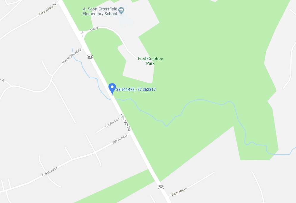
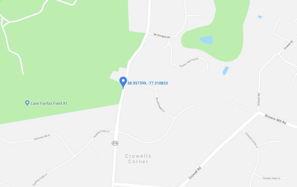
Two roads in the Reston area are closed due to flooding, according to tweets from the Fairfax County Police Department.
Hunter Mill Road between Hunting Crest Lane and Mount Sunapee Road closed shortly before 4 p.m. today.
Fox Mill Road between Folkstone Drive and Thoroughbred Road in Herndon closed around 2 p.m.
Police advise locals to avoid the area and use alternate routes.
A Flood Watch is in effect for Fairfax County and surrounding areas until midnight, according to the National Weather Service.
More from NWS:
* Until midnight EDT tonight
* A widespread soaking rain around 2 inches is expected. Isolated amounts of around 3 inches are possible. The steadiest rain is expected through 6 pm this evening, with residual runoff possibly persisting through late this evening.
* These rainfall amounts may cause small streams and creeks to go out of their banks, as well as cause flooding of low-lying, urban and poor drainage areas.
TRAFFIC ALERT: Hunter Mill Rd is closed between Hunting Crest Ln and Mount Sunapee Rd in Reston due to water in the roadway. Please avoid the area and use an alternate route. #FCPD #TurnAroundDontDrown pic.twitter.com/7rjes9vCMT
— Fairfax County Police (@FairfaxCountyPD) March 21, 2019
TRAFFIC ALERT: Fox Mill Rd is closed between Folkstone Dr and Thoroughbred Rd in Herndon due to water in the roadway. Please avoid the area and use an alternate route. #FCPD #TurnAroundDontDrown pic.twitter.com/043T2TkLSZ
— Fairfax County Police (@FairfaxCountyPD) March 21, 2019
Images via Google Maps
")
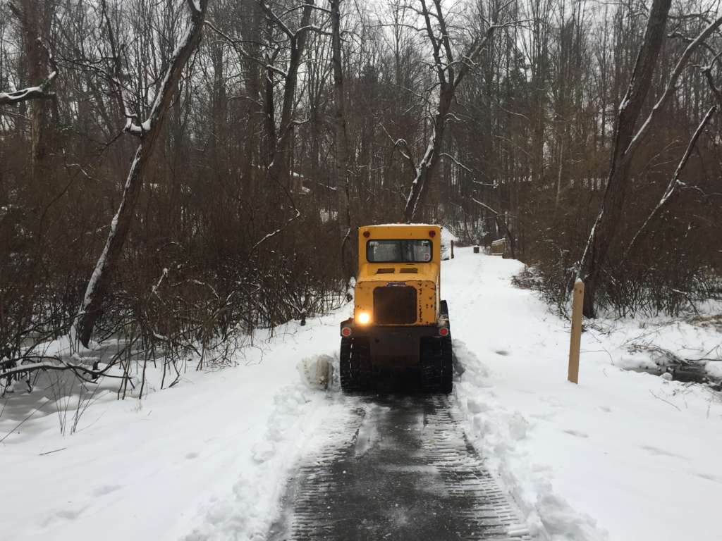
Locals can expect warmer temperatures later today, yet they should still be careful about ice and slick roads around Reston and Herndon today.
The D.C.-area could feel a high up to 52 degrees today, according to the National Weather Service. Yesterday’s rain and sleet after the snowstorm hit might create hazardous road conditions this morning.
The Virginia Department of Transportation is warning locals about icy spots and to be careful of any debris in the roadways. If you plan on walking outside, Fairfax County Fire and Rescue suggests a side-to-side “penguin” walk on any potentially icy ground.
Speaking of getting around, the Fairfax Connector is back to its regular service schedule today.
Melting, rain, melting, rain will be our pattern for the next few days.
💧 Icy spots this AM
💧 Headlights ON
💧 Watch for ponding & roadspray
💧 Watch for downed trees/debris
💧 Don’t go around road closed signs 🙄
💧 Report road hazards: https://t.co/12wxgee8pi or 800-FOR-ROAD pic.twitter.com/BWw3MxKgs6— VDOT Northern VA (@VaDOTNOVA) February 21, 2019
Be aware of icy spots out there this morning. Walk with caution and drive with care. Also clear snow and ice off the roof of your car! #FCFRD #FairfaxCounty pic.twitter.com/0saIHmfhrN
— Fairfax County Fire/Rescue (@ffxfirerescue) February 21, 2019
Photo via @greatfallsva/Instagram
Updated at 4:45 p.m. — Fairfax County Public Schools announced that schools will open two hours late tomorrow (Feb. 21). School offices and central offices will open on time.
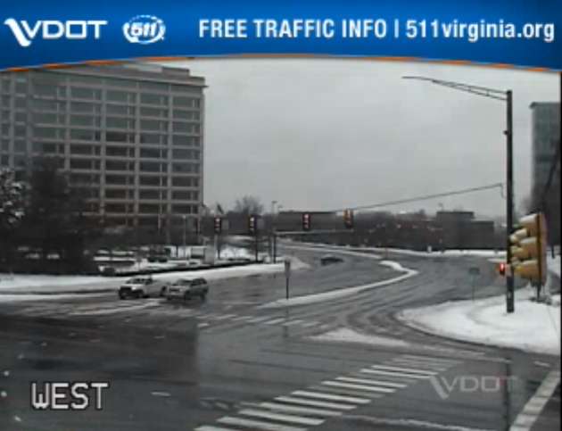
Earlier: Major roads appear clearer and mostly without traffic this afternoon, yet public safety officials keep asking locals to stay off of the roadways.
An emergency post from Fairfax County said that a number of traffic accidents took place today (Feb. 20) around the county. With sleet and rain recently replacing the snow, locals can expect slippery roads, the National Weather Service warns.
Herndon and Reston saw around 4.5 inches of total snow accumulation, according to NWS.
With the majority of the snow now changed over to sleet/ freezing rain, attention is turned to ice accumulations as temperatures only gradually warm above freezing. Advisories & Warnings continue through the evening, with the greatest ice accumulations north/west of I-95. pic.twitter.com/uNqXPPgPyB
— NWS Baltimore-Washington (@NWS_BaltWash) February 20, 2019
Several locals posted photos noting the change this afternoon from snow to a wintry mix of sleet and rain.
Sleet eroding snow in Reston @capitalweather pic.twitter.com/b7xIVFUUNr
— Bill Burton (@burtonwc) February 20, 2019
Looks like we are at around 4” in Reston @capitalweather – mostly sleet coming down at this point. pic.twitter.com/DKiM3TlzwD
— C. G. Niederstrasser (@RocketScient1st) February 20, 2019
https://twitter.com/hollyweatherwax/status/1098248450783760385
A Winter Weather Advisory is in effect for the county and surrounding area until 10 p.m. for snow, sleet and ice.
More from NWS:
WHAT…Mixed precipitation. Additional snow and sleet
accumulations of less than one inch through mid afternoon, then
ice accumulations of up to one tenth of an inch through 10 pm.
All freezing rain is expected to transition to rain by 10 pm.* WHERE…Portions of central and northern Virginia.
* WHEN…Until 10 PM EST this evening.
* ADDITIONAL DETAILS…Plan on slippery road conditions. The
hazardous conditions will impact the evening commute.PRECAUTIONARY/PREPAREDNESS ACTIONS…
A Winter Weather Advisory means that periods of snow, sleet or
freezing rain will cause travel difficulties. Expect slippery
roads and limited visibilities, and use caution while driving.When venturing outside, watch your first few steps taken on
steps, sidewalks, and driveways, which could be icy and slippery,
increasing your risk of a fall and injury.
The weather has prompted some event cancellations tonight in Reston and Herndon.
Images via Virginia 511, Google Maps and Marjorie Copson
")
Updated at 4:35 — FCPS tweeted that its schools will be closed tomorrow.
Earlier: This time tomorrow, locals in Reston and Herndon can expect snow, sleet and ice from a winter storm slated to hit late tonight.
Forecasts predict that snowfall will start between 3-5 a.m. on Wednesday (Feb. 20) before transitioning into freezing rain with sleet during the late afternoon. Snowfall is then expected to return before rain hits Wednesday night, according to Fairfax County Emergency Information.
The storm will likely leave between 4-6 inches of total snow accumulation and ice, posing risks for road safety.
The National Weather Service issued a Winter Storm Warning today ahead of the harsh, wintry weather.
More from the NWS:
WINTER STORM WARNING REMAINS IN EFFECT FROM 1 AM TO 7 PM EST WEDNESDAY…
* WHAT…Heavy mixed precipitation expected. Total snow accumulations of 3 to 6 inches and ice accumulations of up to one tenth of an inch expected.
* WHERE…The District of Columbia and portions of central Maryland and central and northern Virginia.
* WHEN…From 1 AM to 7 PM EST Wednesday. Snow will overspread the area early Wednesday morning and mix with and change to sleet and freezing rain during the late morning and early afternoon hours Wednesday. Precipitation will change to plain rain Wednesday evening. The heaviest snow is likely Wednesday morning.
* ADDITIONAL DETAILS…Travel could be very difficult. The hazardous conditions could impact the morning or evening commute.
PRECAUTIONARY/PREPAREDNESS ACTIONS…
A Winter Storm Warning means significant amounts of snow, sleet and ice will make travel very hazardous or impossible.
When venturing outside, watch your first few steps taken on steps, sidewalks, and driveways, which could be icy and slippery, increasing your risk of a fall and injury.
The Capital Weather Gang is uring workers to telecommute tomorrow morning. But if commuters do decide to hit the roads, they should “expect very difficult conditions,” the D.C.-area weather group tweeted.
The Virginia Department of Transportation said in a snow update this afternoon that crews have pretreated interstates and major routes throughout northern Virginia and that trucks get set up along roadways tonight so they will be ready to plow and treat roads tomorrow as needed.
Still, VDOT wants locals to “plan now to avoid driving through the day Wednesday and after the storm until conditions have improved.”
⚠️ Winter Storm Warning
⏰ Effective from 1 a.m – 7 p.m. Wednesday
❄️ 4-6 inches of snow and ice accumulations of up to one tenth of an inch
🚘 Hazardous travel conditions are expected
📲Stay informed: https://t.co/PAQyz4nJGn pic.twitter.com/AgVIpzppae— Ready Fairfax (@ReadyFairfax) February 19, 2019
Some places have already started announcing closures on Wednesday.
The Reston Animal Hospital and HealthWorks in Herndon will be closed, and the Greater Reston Chamber of Commerce canceled its events for tomorrow.
If you live in Herndon, don’t put out your recycling tonight. Mayor Lisa Markel posted on Facebook that recycling will be collected on Thursday instead.
Info from @TownOfHerndon: Prior to snow, please move cars off of roads so the snow plows can get through. Recyclables will NOT be picked up Wed, but picked up town-wide on Thu. Trash normally collected on Thurs will be collected on Fri. Updates here: https://t.co/azHcy0RddT pic.twitter.com/CzEGc0sZiy
— Herndon Police (@HerndonPolice) February 19, 2019
Whether you stay bundled inside or venture outdoors, stay safe and send Reston Now any pictures that you snap of the snow to [email protected] or tag us (@restonnow) on social media.
Photo by Marjorie Copson

The county’s public schools and offices are set to close two hours early on Tuesday (Jan. 29) as incoming wintery weather may create hazardous road conditions.
Fairfax County Public Schools tweeted shortly after 5 p.m. today (Jan. 28) that the decision is “due to the anticipated snow and freezing rain in the forecast tomorrow afternoon and evening, and the possibility of deteriorating travel conditions.”
The National Weather Service said an abrupt transition from rain to about 1 to 3 inches of snow could likely create poor driving conditions.
Commuters are encouraged to be aware of potential travel disruptions and allow for extra time getting back in the evening.
Due to the anticipated snow and freezing rain in the forecast tomorrow afternoon and evening, and the possibility of deteriorating travel conditions, all Fairfax County public schools and offices will close two hours early Tuesday, Jan. 29, 2019 (Cond 4). https://t.co/zNBBMjWGwr
— Fairfax Schools 🌟 (@fcpsnews) January 28, 2019
File photo

Rain and snow are slated to hit Fairfax County tomorrow, possibly making roads slick from sudden weather changes.
The National Weather Service recently posted a Winter Weather Advisory at 2:58 p.m. today for Fairfax County and nearby areas beginning tomorrow.
NWS expects rain and snow late in the afternoon and early evening on Tuesday (Jan. 29). NWS anticipates about 1 to 3 inches of snow, with the abrupt transition from rain to snow creating poor driving conditions.
Commuters are encouraged to be aware of potential travel disruptions and allow for extra time getting back in the evening.
The advisory says the following:
WINTER WEATHER ADVISORY IN EFFECT FROM NOON TO 10 PM EST
TUESDAY…* WHAT…Any rain will change to snow during the afternoon hours.
Total snow accumulations of 1 to 3 inches expected.* WHERE…Portions of central and northern Maryland and northern
Virginia.* WHEN…From noon to 10 PM EST Tuesday.
* ADDITIONAL DETAILS…Plan on slippery road conditions. The
hazardous conditions will impact the evening commute.
Temperatures will fall well below freezing during the evening,
causing any moisture or slush to freeze on untreated surfaces.PRECAUTIONARY/PREPAREDNESS ACTIONS…
A Winter Weather Advisory for snow means periods of snow will
cause primarily travel difficulties. Expect snow covered roads
and limited visibilities, and use caution while driving.The latest road conditions for the state you are calling from can
be obtained by calling 5 1 1
From @NWS_BaltWash: If you plan on commuting Tuesday evening, be aware of the potential for travel disruptions. Plan ahead by allowing for extra travel time, and consider using public transportation and telework options. More details: https://t.co/zZL89SPjAy pic.twitter.com/3EfguqmsRi
— Fairfax County Government 🇺🇸 (@fairfaxcounty) January 28, 2019
Be prepared for an impacted Tues PM commute. Snow is forecast to hit around that time. Be aware that temps will drop (freezing) and the winds will pick up. Pls plan to leave work or be home a little early. Clear the roads so we can clear the roads. #teamwork pic.twitter.com/TuDjXbw29S
— VDOT Northern VA (@VaDOTNOVA) January 28, 2019
File photo