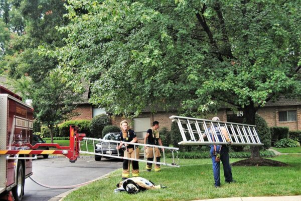
Flood Watch in Effect — A flood watch is in effect though the afternoon today. So be on the lookout for potential flooding. [Fairfax County Fire and Rescue Department]
Herndon Man Allegedly Uses Belt to Restrain Student — A music teacher from Herndon tried to restrain a disruptive student with his belt at an elementary school Sept. 15 in Fauquier County, police said. The 23-year-old was charged Monday with assault, battery and contributing to the delinquency of a minor, and he was placed on administrative leave pending an investigation. [Fauquier County Sheriff’s Office]
Reston Multicultural Festival Returns — The annual festival, which is organized by Reston Community Center, returns to Lake Anne Plaza on Saturday. [WUSA9]
Feedback on Bus Service Sought — The county’s Department of Transportation is seeking the public’s feedback as it explores ways to improve the Fairfax Connector’s bus service. [Patch]
The National Weather Service issued a Flood Watch for much of the Washington, D.C., metropolitan area, for early Wednesday morning, forecasting a day of strange, wet weather for local residents.
The county is also under a winter weather advisory after the NWS predicted yesterday afternoon that the area will see between one and three inches of snow and sleet accumulation. That advisory is in effect from 10 a.m. today to 1 a.m. on Thursday.
According to the NWS, potential flooding could take place from 4 p.m. today through Thursday morning. The agency is projecting that the D.C. area will see one to two inches of rainfall, which could lead to isolated flooding, especially when coupled with earlier precipitation.
“You should monitor later forecasts and be alert for possible flood warnings,” the NWS said. “Those living in areas prone to flooding should be prepared to take action should flooding develop.”
Photo via vantagehill/Flickr

Update at 12:30 p.m. — The National Weather Service has now upgraded central Fairfax County and the City of Fairfax from a flood watch to a flood warning, which will remain in effect until 4 p.m.
As of 12:03 p.m., between one and two inches of rain have fallen in the county, and an additional one to two inches of rain could potentially fall in the area covered by the flood warning. Reston is among the locations considered at risk of flooding.
Earlier — A Flood Watch is in effect for most of the region until 10 p.m. today, according to the National Weather Service.
Remnants of Hurricane Zeta are expected to dump two to three inches of rain on the area.
NWS warns that heavy rain could lead to flooding of small streams, creeks, and urban areas. Clogged drains due to leaf buildup might also cause flooding issues.
Here’s more from the alert:
Do not enter or cross flowing water or water of unknown depth. Stay away or be swept away. River banks and culverts can becom unstable and unsafe.
A Flood Watch means there is a potential for flooding based on current forecasts. You should monitor later forecasts and be alert for possible flood warnings. Those living in areas prone to flooding should be prepared to take action should flooding develop.
Grab your umbrella ☔️ Rain 🌧️ from #Zeta is going to cause a wet commute for drivers today.
When driving in the rain remember
💡 headlights & wipers on
🚘 increase following distance
🐢 slow down
💧 #TurnAroundDontDrown
👁️ be alert for pedestrians & other road users pic.twitter.com/krPQMJhevB— VDOT (@VaDOT) October 29, 2020
Informal Survey on Reston Association Website Underway — “Reston Association is conducting an informal survey to determine what features its membership would find most important in a new RA website. As part of the preliminary research in choosing a vendor and a website platform that meets the current and future needs of the association, please click the link below to take the online survey.” [RA]
Native American Campfire Cookout Returns to Riverbend Park — Residents can learn how early Native Americans lived off the land by learning special recipes and cooking techniques. The event takes place on Nov. 14 and Nov. 21. [Fairfax County Government]
Flood Watch In Effect — A Flood Watch is in effect until 10 p.m. this evening. Remnants of former Hurricane Zeta may result in two to three inches of rain. [Fairfax County Fire and Rescue Department]
Photo by Elizabeth Copson

Prepare for a wet beginning to the workweek.
A flood watch is in effect from this evening through Tuesday evening as Tropical Storm Isaias makes its way to the region.
A severe thunderstorm warning is also in effect until 4:30 p.m. today.
A potential for between three to six inches of rain is possible.
Here’s more from the National Weather Service:
* RAINFALL ASSOCIATED WITH TROPICAL STORM ISAIAS IS EXPECTED T START SPREADING NORTHWARD LATE MONDAY NIGHT AND CONTINUE INTO TUESDAY EVENING. WIDESPREAD RAINFALL TOTALS OF 3 TO 6 INCHES ARE EXPECTED WITH LOCALIZED HIGHER AMOUNTS POSSIBLE.
* THIS AMOUNT OF RAIN IS LIKELY TO RESULT IN SIGNIFICANT FLASH FLOODING OF SMALL STREAMS AND CREEKS MONDAY NIGHT INTO TUESDAY EVENING.
PRECAUTIONARY/PREPAREDNESS ACTIONS…
A FLASH FLOOD WATCH MEANS THAT CONDITIONS MAY DEVELOP THAT LEAD TO FLASH FLOODING. FLASH FLOODING IS A VERY DANGEROUS SITUATION. YOU SHOULD MONITOR LATER FORECASTS AND BE PREPARED TO TAKE ACTION. SHOULD FLASH FLOOD WARNINGS BE ISSUED
File photo

A flash flood watch is in effect for most of the day today.
The National Weather Service issued an alert that runs from 10 a.m. through 10 p.m. this evening.
Heavy rainfall, with the potential for flooding, is expected, according to the NWS.
Here’s more from the county on the alert:
Widespread rainfall totals of 1 1/2 to 2 1/2 inches are expected with locally higher amounts of three inches or more possible.
This amount of rainfall will likely result in small stream and main stem river flooding. Moderate river flooding is also possible.
You should monitor later forecasts and be alert for possible flood warnings. Those living in areas prone to flooding should be prepared to take action should flooding develop.
Rain will continue through the day across the area. The attached graphic shows high end potential rainfall amounts through the remainder of the event (doesn't include rain that has already fallen). Instances of flooding are likely through the day. pic.twitter.com/eNM3syXqGI
— NWS Baltimore-Washington (@NWS_BaltWash) April 30, 2020
Photo by Jay Westcott

A Flood Watch is in effect for Fairfax County and surrounding areas through Friday morning.
The National Weather Service says flooding is possible based on current forecasts. Here’s more from the alert:
Periods of rainfall will continue to occur through early Friday. The heaviest rainfall potential will begin this afternoon and continue into this evening. Storm total rainfall amounts through Friday morning are expected to range between 1 and 2 inches with isolated amounts near 3 inches possible.
Flooding of poor drainage and low lying areas will be possible, and some smaller streams and rivers may exceed their banks.
Residents should continue to monitor the weather for later forecasts.
Photo via vantagehill/Flickr
Just days after major flooded in the region, a flood watch is in effect in Reston and surrounding areas from 2 p.m. until late tonight.
A flood watch means that there is the possibility of flooding. Local fire and rescue crews are encouraging residents to avoid stalled water and turn around if they see flooded roads.
Here’s more from the National Weather Service’s alert:
Showers and thunderstorms are expected this afternoon and evening. Torrential rainfall may lead to totals exceeding 2 inches in a short period of time. This may cause flash flooding of small streams and other poor drainage urban areas.
PRECAUTIONARY/PREPAREDNESS ACTIONS…
A Flash Flood Watch means that conditions may develop that lead to flash flooding. Flash flooding is a very dangerous situation.
You should monitor later forecasts and be prepared to take action should Flash Flood Warnings be issued.
In the latest storm this past Monday (July 8), the Fairfax Fire and Rescue Department responded to 55 calls related to people being trapped on flooded roadways.
Showers and thunderstorms starting to pop up along the I-95 corridor between DC and Baltimore. Additionally, a line of showers and storms is approaching from the west. Again, damaging winds and heavy rainfall, which could lead to flash flooding, are the main threats today. pic.twitter.com/ulJiTk387d
— NWS Baltimore-Washington (@NWS_BaltWash) July 11, 2019
Photo via vantagehill/Flickr
Sahaja Yoga Meditation — Head to the Herndon Fortnightly Library tonight from 7-8 p.m. for beginner’s yoga meditation. [Fairfax County]
Virginia’s public schools earn high marks — Two recent national studies rank Virginia’s public schools as among the highest performing in the nation. [Virginia Department of Education]
Flood Watch PSA — Fairfax County Fire and Rescue shared some National Weather Service safety tips as the Flood Watch continues until 3 p.m. today. [Fairfax County Fire and Rescue]
Reston’s MLK Day — Whether you attended the events over the weekend or want to know what you missed, this recap takes readers through the three-day celebration. [Connection Newspapers]
Photo via Marjorie Copson
 The National Weather Service (NWS) issued a Flood Watch today (Jan. 23) for late tonight through Thursday afternoon for Fairfax and much of the D.C. region.
NWS anticipates the heaviest rain to fall overnight and Thursday morning.
NWS expects around 1 inch of rain, with 1.5 to 2 inches possible.
NWS encourages locals to monitor later forecasts and to stay alert for possible Flood Warnings. Residents should prepare to take action if they live in areas prone to flooding.
More from the National Weather Service:
FLOOD WATCH REMAINS IN EFFECT FROM LATE TONIGHT THROUGH
THURSDAY AFTERNOON…The Flood Watch continues for
* Portions of Maryland, The District of Columbia, and Virginia,
including the following areas, in Maryland, Anne Arundel,
Carroll, Central and Southeast Howard, Central and Southeast
Montgomery, Charles, Frederick MD, Northern Baltimore,
Northwest Harford, Northwest Howard, Northwest Montgomery,
Prince Georges, Southeast Harford, and Southern Baltimore. The
District of Columbia. In Virginia, Arlington/Falls
Church/Alexandria, Eastern Loudoun, Fairfax, Northern
Fauquier, Prince William/Manassas/Manassas Park, Southern
Fauquier, Spotsylvania, Stafford, and Western Loudoun.* From late tonight through Thursday afternoon
* Rain will overspread the area this evening and overnight. The
heaviest rain is expected overnight and Thursday morning. Total
rainfall amounts around 1 inch are expected, with isolated
higher amounts of 1.5 to 2 inches possible.* Excess runoff from a nearly frozen ground and saturated soils
will cause the potential for streams and creeks to rise out of
their banks as well as potential flooding in low lying urban
areas.PRECAUTIONARY/PREPAREDNESS ACTIONS…
A Flood Watch means there is a potential for flooding based on
current forecasts.You should monitor later forecasts and be alert for possible
Flood Warnings. Those living in areas prone to flooding should be
prepared to take action should flooding develop.
The @NWS has issued a Flood Watch for @fairfaxcounty from this evening through Thursday afternoon. Heaviest rain expected overnight into early Thursday, with 1-1.5" possible. Be aware and be prepared! Info: https://t.co/6E2sMi5MHv #VAwx #Weather #FCFRD !� pic.twitter.com/eKjYR0a3Pq
— Fairfax County Fire/Rescue (@ffxfirerescue) January 23, 2019
Photo via Bahmad Farzad/Flickr
 The National Weather Service (NWS) issued a Flood Watch today (Dec. 20) starting from 7 p.m. Thursday to Friday afternoon for Fairfax and much of the D.C. region.
NWS anticipates widespread rain tonight and showers tomorrow.
NWS expects 1 to 2 inches of rain, but up to 4 inches of rain could fall in local areas.
NWS encourages locals to monitor later forecasts and to stay alert for possible Flood Warnings. Residents should prepare to take action if they live in areas prone to flooding.
More from the National Weather Service:
FLOOD WATCH REMAINS IN EFFECT FROM 7 PM EST THIS EVENING
THROUGH FRIDAY AFTERNOON…The Flood Watch continues for
* Portions of Maryland, The District of Columbia, Virginia, and
West Virginia, including the following areas, in Maryland,
Anne Arundel, Calvert, Carroll, Central and Southeast Howard,
Central and Southeast Montgomery, Charles, Frederick MD,
Northern Baltimore, Northwest Harford, Northwest Howard,
Northwest Montgomery, Prince Georges, Southeast Harford,
Southern Baltimore, St. Marys, and Washington. The District of
Columbia. In Virginia, Albemarle, Arlington/Falls
Church/Alexandria, Augusta, Central Virginia Blue Ridge,
Clarke, Culpeper, Eastern Loudoun, Fairfax, Frederick VA,
Greene, King George, Madison, Nelson, Northern Fauquier,
Northern Virginia Blue Ridge, Orange, Page, Prince
William/Manassas/Manassas Park, Rappahannock, Rockingham,
Shenandoah, Southern Fauquier, Spotsylvania, Stafford, Warren,
and Western Loudoun. In West Virginia, Berkeley, Hampshire,
Hardy, Jefferson, and Morgan.* From 7 PM EST this evening through Friday afternoon
* Widespread rain is expected tonight and showers are expected
Friday. Rainfall amounts around 1 to 2 inches are most likely,
but locally higher amounts around 3 to 4 inches are possible.
Soils remain saturated due to recent rainfall, so excess
runoff from the rain will cause the potential for flooding of
small streams, creeks, and urban areas.
MT @ffxfirerescue: Be aware and prepared! PLEASE remember to NOT drive through a flooded roadway. That includes NOT driving around barriers closing the road! Several folks last week learned the hard way that this is a poor decision. #TurnAroundDontDrown https://t.co/ZhGHwoYiNB
— Fairfax County Government 🇺🇸 (@fairfaxcounty) December 20, 2018
Photo via Bahmad Farzad/Flickr
 The National Weather Service issued a Flood Watch today (Dec. 13) from Friday evening to Saturday afternoon for Fairfax and much of the D.C. region.
NWS anticipates 1 to 2 inches of rainfall — possibly up to 3 inches.
NWS encourages locals to monitor later forecasts and to stay alert for possible Flood Warnings.
Residents should prepare to take action if they live in areas prone to flooding.
More from the National Weather Service:
The National Weather Service in Sterling Virginia has issued a
* Flood Watch for portions of Maryland, The District of
Columbia, and Virginia, including the following areas, in
Maryland, Anne Arundel, Calvert, Carroll, Central and
Southeast Howard, Central and Southeast Montgomery, Charles,
Frederick MD, Northern Baltimore, Northwest Harford, Northwest
Howard, Northwest Montgomery, Prince Georges, Southeast
Harford, Southern Baltimore, and St. Marys. The District of
Columbia. In Virginia, Albemarle, Arlington/Falls
Church/Alexandria, Culpeper, Eastern Loudoun, Fairfax, Greene,
King George, Madison, Nelson, Northern Fauquier, Orange,
Prince William/Manassas/Manassas Park, Rappahannock, Southern
Fauquier, Spotsylvania, Stafford, and Western Loudoun.* From Friday evening through Saturday afternoon
* Moderate rainfall is expected with locally heavy rain possible.
Rainfall amounts around 1 to 2 inches are most likely with
locally higher amounts around 3 inches possible. Runoff from the
rainfall may cause creeks and streams to rise out of their
banks as well as the potential for flooding in urban areas.
Heads up! With all of the rain in the forecast the National Weather Service has issued a flood watch for the entire area from 6PM Friday until 6PM Saturday. We will have rain arriving later tomorrow and continuing at times through the weekend w/1-2" total pic.twitter.com/BMwXGIOwS3
— Amelia Draper (@amelia_draper) December 13, 2018
Photo via Bahmad Farzad/Flickr
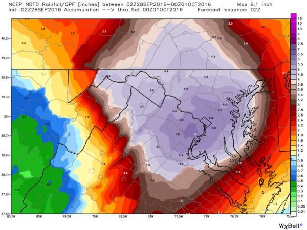 After heavy rains and gusty winds overnight, the rain and potential flooding will continue through Thursday.
In Reston, there are many downed branches on roads and sidewalks. There are no major power outages reported.
More than two inches of rain fell overnight, hitting the southern portion of Fairfax County hard. A flood warning remains in effect until 10:45 a.m. for the areas closer to I-95 (Alexandria, Springfield, Burke, Fairfax City and others). Reston remains under a flood watch through Friday.
The Capital Weather Gang says and additional three inches of rain will fall today, and Reston may see a total of six inches by the time this front moves away on Friday.
Graphic: Storm front for Sept. 29/Credit: WeatherBell.com
 Wherever you are heading today, bring your umbrella and drive carefully.
The National Weather Service has issued a Flood Watch for Reston, Fairfax County and most of the DC area. The Flood Watch is in effect from 10 a.m. Wednesday until midnight.
From the NWS:
Showers and thunderstorms, heavy at times, are expected to move Northeast across the area this afternoon into evening. Widespread rainfall amounts around one inch are expected, with localized high amounts up to 3 inches possible in areas of repeated activity.
Due to saturated ground, rains will turn into runoff with flooding of smaller streams and creeks possible. General inundation of low-lying and urban flooding in poor drainage areas also possible.
A flood watch means there is a potential for flooding based on current forecasts. You should monitor later forecasts and be alert for possible flood warnings.
 Melting snow plus heavy rain could equal a big mess for Reston and the rest of Northern Virginia on Wednesday.
The National Weather Service has issued a flood watch beginning at noon Wednesday through late Wednesday night for most of the Washington, DC area.
From the NWS:
… FLOOD WATCH IN EFFECT FROM NOON EST TODAY THROUGH LATE TONIGHT…
* THE COMBINATION OF MELTING SNOW AND PERIODS OF HEAVY RAIN COULD RESULT IN FLOODING OF URBAN AREAS AND STREAMS THIS AFTERNOON AND TONIGHT. RAINFALL AMOUNTS WILL AVERAGE BETWEEN ONE HALF AND ONE INCH… WITH ISOLATED SPOTS BETWEEN ONE AND TWO INCHES POSSIBLE.
* IN ADDITION… ICE MAY BE ON SOME OF THE SMALL STREAMS WHICH COULD ENHANCE THE FLOODING POTENTIAL.
PRECAUTIONARY/PREPAREDNESS ACTIONS…
A FLOOD WATCH MEANS THERE IS A POTENTIAL FOR FLOODING BASED ON CURRENT FORECASTS. YOU SHOULD MONITOR LATER FORECASTS AND BE ALERT FOR POSSIBLE FLOOD WARNINGS. THOSE LIVING IN AREAS PRONE TO FLOODING SHOULD BE PREPARED TO TAKE ACTION SHOULD FLOODING DEVELOP.
Photo: Rain/Credit: Bahmad Farzad via Flickr


