")
Despite a toll increase that went into effect in January, more drivers are using the Dulles Toll Road than the Metropolitan Washington Airports Authority anticipated.
Between January and March, tolls brought in $46.4 million — 31 percent more compared to the same period last year. That gives the MWAA $11.2 million to work with in order to fund phase two of the Silver Line.
Even though the number of toll transactions dipped by 4.8 percent compared to the previous year, transactions were 1.3 percent higher than MWAA expected. So far this year, there have been 21.7 million transactions.
The cost of operations also increased this year. Year-to-date expenses were $1.3 million or 17 percent higher than the same period last year. MWAA attributed this increase to $1 million in operating expenses for expanded service and $300,000 in transaction fees.
Toll prices increased for the first time in four years from $2.50 to $3.25 and from $1 to $1.50 at ramps in order to cover phase two of the Silver Line past Reston Town Center to Dulles International Airport and Ashburn. Another increase is expected in 2023.
Photo via MWAA

As construction gears up for widening Route 7 from Reston to Tysons, “Pardon Our Dust” meetings starting later this spring with information on the upcoming work phases and schedules.
The proposed Virginia Department of Transportation (VDOT) project will transform nearly seven miles of Route 7, between Reston Avenue and Jarrett Valley Drive, which is just before the Dulles Toll Road interchange.
 The project will widen Route 7 from four to six lanes, add shared-use paths and revamp intersections along the corridor.
The project aims to “increase capacity, improve safety and traffic flow and enhance mobility for cyclists and pedestrians, all in conformity with Fairfax County’s Comprehensive Plan,” according to VDOT.
Washington Gas has been busy with work along the corridor to replace a little under 7 miles of pipeline along Route 7 from Bishop Gates Way in Herndon to the intersection of Baron Cameron Avenue and Springvale Road.
The schedule for the project on VDOT’s website says:
- late summer 2018-summer 2020: final design
- early 2019-early 2021: right of way
- spring 2019-summer 2023: utility relocation
- spring 2019-summer 2024: construction
The project is slated to finish in July of 2024, VDOT says.
Specific dates and locations for the “Pardon Our Dust” meetings, which will periodically occur from this spring through summer 2023, have not been announced yet.
Map via Virginia Department of Transportation

As you head out for your commute this morning, be wary of several road closures in Reston due to water in the roadway. A complete list, updated at 10:40 a.m. today, is below.
- 10050 block of Browns Mill Road – Mud and water in the roadway
- Hunter Mill Road at Hunter Station Road – Water in the roadway
- Hunter Mill Road at Cedar Pond Drive – Water in the roadway
This story was updated to include the most recent road closures.
")
A number of roads remain closed after Monday night’s thunderstorm swept through the area.
According to the Fairfax County Police Department, the following roads are impacted:
- 9200 block Weant Drive – Tree down
- Maria Avenue/River Bend Road – Tree and wires down
- Minburn Street/Golden Arrow Street – Wire in the roadway
- Robindale Drive/Mill Valley Court – Tree down
- 680 River Bend Road – Trees and wires down
A flash flood watch remains in effect for Fairfax County from 3 p.m. today through Wednesday at 1 a.m.
A couple of rounds of thunderstorms are expected through push through northern Virginia and parts of northern Maryland in the evening.
Here’s more from the weather alert:
A front will sag across the region this afternoon into this
evening. A couple rounds of thunderstorms are expected to
accompany the front and should move across the Mason-Dixon
region late afternoon. These thunderstorms should push farther
south and east into eastern West Virginia, northern Virginia
and portions of northern Maryland during the evening. Heavy
rainfall and lightning will be the main threats with the
potential of encountering damaging winds and hail in the
strongest thunderstorms. Rainfall amounts could average 1 to 3
inches later this afternoon and this evening. Flash flooding
is possible, especially in slow-moving thunderstorms.
This story will be updated.
Photo by Douglas Errett
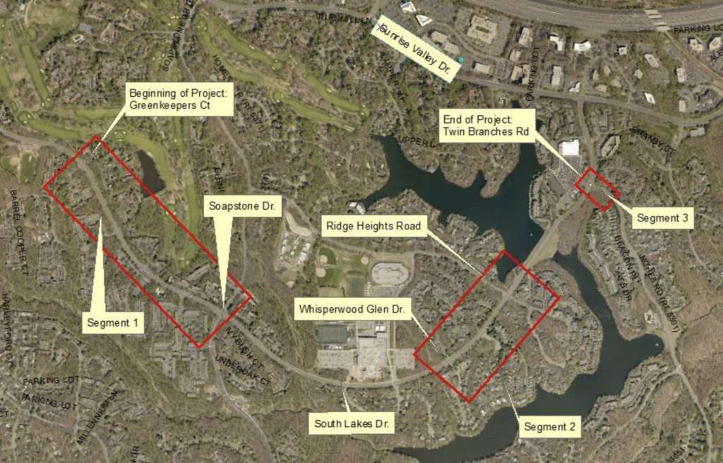
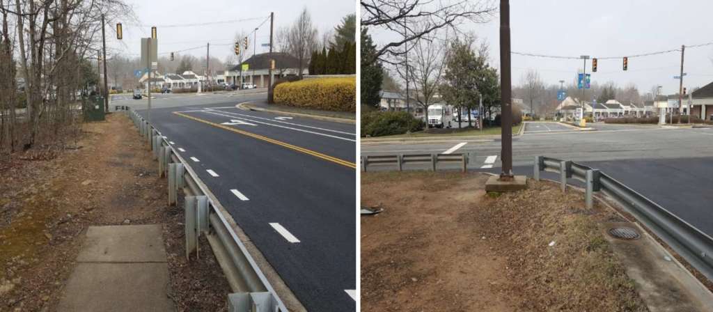
Expanded and upgraded sidewalks are planned on South Lakes Drive between Green Keepers Court and Twin Branches Road.
The Fairfax County Department of Transportation will provide information about the proposal at Reston Association’s Design Review Board on Tuesday (May 15) at 7 p.m. in Reston Association’s Conference Center.
In total, roughly 3,600 feet of sidewalk will be installed in the area, along with a bus shelter on Green Watch Way. Upgrades to curb ramps and six bus stops with ADA-compliant loading pads are also planned.
The project is divided into three segments: from Greenkeepers Court to Pond View Court, from Salt Kettle Way to Ridge Heights Road and from South Lakes Drive at Twin Branches Road.
The Virginia Department of Transportation plans to rebuild the traffic signal at the intersection of South Lakes Drive and Twin Branches Road. Currently, a sidewalk does not extend to the intersection.
Land acquisition is expected to begin in the fall and be complete by fall 2019. Construction should begin around spring 2020, according to estimates from county officials.
Map/photo via FCDOT
")
The right lane of Reston Parkway at the intersection of Sunrise Valley Drive will be closed for parts of the week.
Dulles Corridor Metrorail crews will complete drill testing related to the traffic signal.
Closures will remain in effect today (April 23) through Thursday (April 26) from 9:30 a.m. to 3:30 p.m. and on Friday (April 27) from 9:30 a.m. to noon.
Drivers should pay attention to all signage and traffic barriers, as large, slow vehicles may exit and enter the highway at various times throughout the week.
Map via Dulles Corridor Metrorail Project

Prepare for a sea of orange cones. With spring quickly approaching, Virginia Department of Transportation officials are gearing up for re-stripping, road redesigns, and new bike lanes on multiple Reston roads this year.
Roadwork will take place from April through November. The Virginia Department of Transportation is holding a public meeting on plans on Monday, March 19 at 7 p.m. in Terraset Elementary School‘s cafeteria.
In response to residents’ concerns about safety along the South Lakes Drive corridor, the county plans to redesign a strip between Reston Parkway and Sunrise Valley Drive by converting an outside travel lane to a buffered bike lane — a move the county hopes will address concerns about limited sight distance for vehicles turning onto Sunrise Valley Drive and pedestrian traffic.
Bike lanes on South Lakes Drive between Reston Parkway and Sanibel Drive would be extended. The county will keep one travel lane in each direction due to the limited projected impacts of future development on traffic in that area.
Other plans include adding or expanding bike lines on Bennington Woods Drive, Bowman Towne Drive, Explorer Street, Lawyers Road, Pinecrest Road and others. South Lakes Drive, Bluemont Drive and Fountain Drive are slated for redesigning.
A complete breakdown of plans in the Hunter Mill District is below:
- Bennington Woods Drive: Addition of bike lanes.
- Bowman Towne Drive: Addition of northbound bike lane, southbound shared line markings and striped parking lanes on both sides.
- Bracknell Road: Addition of buffered bike lanes between Stevenage Road and commercial driveways.
- Explorer Street: Addition of bike lanes. On-street parking on both sides of the street will remain.
- Fountain Drive: Road redesign to “increase traffic safety.” There will be one travel lane in each direction, with one dedicated left turn lane and buffered bike lanes.
- Stevenage Road: Addition of buffered bike lanes between Bennington Woods Road and the northern Home Depot driveway and Reston Parkway. Existing parking restrictions will not be changed. Timed parking will remain.
- Temporary Road: Addition of bike lanes.
- Walnut Branch Road: Addition of eastbound buffered bike lanes and westbound shared lane markings.
- Lawyers Road: Extension of existing bike lanes west to Reston Parkway and upgrades to existing shoulders between Twin Branches Road to Hunter Mill Road to buffered bike lanes.
- Pinecrest Road: Addition of buffered lanes between South Lakes Drive and Glade Drive. On-street parking will remain.
- Ridge Heights Road: Addition of bike lanes. On-street parking will remain. “Extra wide” parking lanes will be provided for school bus parking.
- Soapstone Drive: Addition of buffers to existing bike lanes.
In addition to attending the meeting, residents can submit online feedback. A complete list of impacted is online.
Photo via Fairfax County Government
 Plans to extend Soapstone Drive could move forward as Fairfax County officials seek public comment tonight on the project, which would create an additional crossing on the Dulles Toll Road for cars, pedestrians and cyclists.
At Dogwood Elementary School (12300 Glade Drive) from 6:30 – 8:30 p.m., the floor will be open for the public to comment on a environmental assessment completed as part of a multi-step process since the Board of Supervisors approved the project in 2014. The study examines the potential effects of the project for properties listed in or eligible for the National Register of Historical Places, the country’s official list of historic sites worthy of preservation.
The new roadway will provide a half-mile extension between Sunrise Valley Drive and Sunset Hills Road and a new crossing over the Dulles Corridor. County officials have said the project is necessary to tackle congestion on Wiehle Avenue, limited access for buses to Wiehle-Reston East Station and the lack of connectivity for pedestrians and bicyclists in the area.
Completed in August, the assessment reviews impacts of the project on surrounding land. For example, the assessment finds the project rests within 200 feet of on two sites with hazardous materials and would result in increased noise for two areas near the project.
Overall, the assessment concludes the project will not “contribute substantially to cumulative impacts, particularly in light of the efforts to minimize adverse impacts of the project and other mitigation measures to be implemented.”
Following the public hearing, the county will revise the assessment as needed and submit it to the Federal Highway Administration, the body which will make a decision about the feasibility of the project.
In 2014, the county’s supervisors included $2.5 million for the preliminary design of this project as part of its Six Year Transportation Project Priorities. At that time, they also put the project — estimated to cost $91.75 million — on the county’s list of high-priority projects for 2015-20.
More information on the project is available on the county’s website. Written or oral comments may be submitted at the hearing or in writing within 10 days after the hearing to [email protected]. Include “Soapstone Connector” in the subject line.
 A number of Reston paving projects have been scheduled by the Virginia Department of Transportation for this year.
According to VDOT’s website, more than 1,300 miles of roads will be repaved in Fairfax, Prince William, Loudoun and Arlington counties during the 2017 paving season. Among the scheduled projects are the following locations in Reston:
- the entire length of North Shore Drive (3.53 miles)
- the entire length of Colts Neck Road (1.82 miles), excluding the intersection with Glade Drive
- 1.93 miles of Glade Drive, from Glade Bank Way to Twin Branches Road
- 2.21 miles of Stuart Mill Road, from Fox Mill Road to Birdfoot Lane
- 1.07 miles of North Village Road, from Baron Cameron Avenue to Hollow Timber Way
- the entire length of Twin Branches Road (.85 miles)
- the entire length of Triple Crown Road (.43 miles)
- .13 miles of Wiehle Avenue, from Reston Parkway to Reston Avenue
In addition, the Fairfax County Department of Transportation has plans to make alterations to lane patterns and bike lanes on North Shore Drive, Colts Neck Road and Twin Branches Road as part of the repaving process. A community meeting on this issue is scheduled for March 16.
VDOT’s website shows the only repaving work completed in Reston in 2016 was along a stretch of Baron Cameron Avenue, from Leesburg Pike (Route 7) to near Browns Chapel Road.
Other roads in the area on the 2017 schedule include portions of Centreville Road, Frying Pan Road and McLearen Road in Herndon; and Lee Jackson Memorial Highway (U.S. Route 50) at the Fairfax County Parkway interchange.
VDOT says repaving work is “usually limited to outside of rush hours,” with work in residential areas typically scheduled from 9 a.m. to 3 p.m. on weekdays.
Check VDOT’s interactive map for more.
Map via VDOT

Roads in Good Shape for Morning Commute — The Virginia Department of Transportation says overnight winds assisted road crews by drying most of the region, but low pavement temperatures will quickly refreeze any additional moisture. [VDOT]
Animal Protection Police Come to the Rescue — The Fairfax County Police Department shared a photo Thursday of a raccoon that got tangled up while trying to get into a bird feeder in Reston. Police said “No harm, no fowl!” — [Fairfax County Police Department/Twitter]
RA Committees to Meet Next Week — The Reston Association meeting schedule for the week of Feb. 13-17 includes meetings of the Board Governance, Elections, 55+ Advisory, Covenants and Multimodal Transportation Advisory committees. [Reston Association]
 The Reston advisory group looking at ways to raise $2.6 billion to fund Reston road improvements over the next 40 years says it is strongly opposed to a special tax district for new development in Reston’s transit station areas.
The Reston Network Analysis Advisory Group (RNAG) last month approved a document containing high level feedback on the funding plan. It will provide an update to the Fairfax County Board of Supervisors’ Transportation Committee on Tuesday.
RNAG says:
Public revenues should be responsible for the roadway improvements and private revenues would be responsible for intersection and grid improvements.
Tax Districts should be removed from further discussion — there is unanimity from the group that a tax district is unrealistic and should be taken off the table.
The transit areas are expected to see the greatest level of development — and will need the most street grid, lane additions and traffic signals, among other improvements — as Reston grows over the next three decades.
FCDOT’s Janet Nguyen has said $1.34 billion in transportation projects will likely come from shared public and private contributions. That money would go for road widening, intersection improvements, the Soapstone overpass, and an Dulles Toll Road underpass near Reston Town Center, among other projects.
The $1.28 billion grid network in the transit station areas — which the RNAG is currently studying — would mostly be funded by developers (and a possible service district, not a special tax district. A service district is imposed by the Board of Supervisors on a geographic area.). An urban grid is important to improve walkability and slow traffic, transportation officials say.
The county and RNAG have been looking at a variety of scenarios to fund the projects. Among the suggestions has been creating a tax district similar to the Metro special tax district or a service district, similar to Tysons (rate is .05 cents per $100 of tax assessment).
A service district is established by the Board of Supervisors and does not need to be approved by residents.
The Board of Supervisors hopes to approve a funding plan by late 2016 or early 2017.
See the Tuesday presentation prepared by FCDOT on the Fairfax County website.
See a list of expected big-ticket Reston road projects below.


The Virginia Department of Transportation has launched a new website that can tell you which roads near you are undergoing — or will be undergoing — construction and repairs.
The interactive portal, www.Virginiaroads.org, provides a one-stop information source to VDOT data and projects, Virginia Gov. Terry McAullife said in announcing the project.
From the office of the governor:
An important feature of this new portal are interactive maps showing current and planned road construction projects included in the Six-Year Improvement Program as well as pavement conditions and resurfacing projects. Some of the data made available through this app is in response to requests by Virginia broadband providers to have greater visibility and earlier notice regarding road construction and repair projects. Providing access to this data will facilitate coordination between VDOT and broadband providers seeking to build new infrastructure.
“Virginiaroads.org is a prime example of the type of project I envisioned when we launched our Data. Virginia initiative aimed at using data to make government more transparent,” said Gov. McAuliffe. “It’s as simple as clicking on the link, selecting a location and seeing in a glance the status of current and future transportation projects. The information is easily accessible and open for to the public to see how their taxpayer dollars are being invested to improve Virginia’s road system.”
Virginiaroads.org features a series of interactive maps in a central online location. Maps display current construction projects, projects in the design phase, projects scheduled to go to construction and future projects. Projects can be searched via project stage, location, route or street name and the project identification number as it is listed in the Six-Year Improvement Program.
Another map shows pavement conditions, with colors identifying whether a section of pavement is in excellent, good, fair or poor condition. You can click on a section of pavement to find out more details on resurfacing projects.
Other maps on the site
- 511 real-time traffic information
- Park and ride lots
- Snow plowing status
- Virginia toll facilities
- Major road construction
- Highway safety corridors
- Truck routes
- Scenic roads
- Bicycling maps
- Capital trail
- State maps
- City maps